Assateague Island
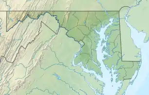
Assateague Island ist eine unbewohnte amerikanische Insel in Maryland und Virginia.[1] Die längliche Düneninsel an der Ostküste der Vereinigten Staaten von Amerika ist in Nord-Süd-Richtung 60 km lang. Die Vereinten Nationen haben Assateague Island zum Biosphärenreservat erklärt. Das Innenministerium der Vereinigten Staaten hat die gesamte Insel zum National Natural Landmark erklärt.
| Assateague Island | ||
|---|---|---|
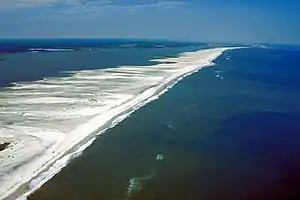 Luftbildaufnahme der Insel | ||
| Gewässer | Atlantischer Ozean | |
| Geographische Lage | 38° 5′ N, 75° 13′ W | |
| ||
| Länge | 60 km | |
| Einwohner | unbewohnt | |
Auf der Insel finden sich Marschland, Buchten, Sandstrände und Sandbuchten.[2]
Es gibt drei Naturschutzbehörden auf der Insel, die zuständig sind:
- Maryland (beide IUCN-Kategorie V)
- Assateague Island National Seashore
- Assateague State Park (3,2 km²)
- Virginia
- Chincoteague National Wildlife Refuge, 57 km² (IUCN-Kategorie IV).
Auf der Insel existieren wildlebende Assateague-Ponys (Chincoteague).[3]
Die Grenze zwischen den Bundesstaaten auf der Insel ist durch einen hohen Zaun markiert. Die Freiwillige Feuerwehr Chincoteague Volunteer Fire Department in Chincoteague (Virginia) besitzt die größte Herde der Chincoteague-Ponys auf dem Eiland.
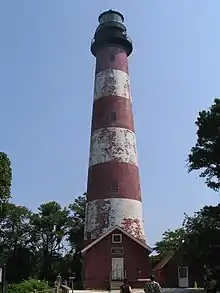
An der Virginia Eastern Shore befindet sich der Leuchtturm Assateague Lighthouse aus den 1830er Jahren mit einer Höhe von 43 m am Südende von Assateague Island. Es ist im National Register of Historic Places eingetragen.
Siehe auch
Literatur
- John Amrhein jr.: The Hidden Galleon: The True Story of a Lost Spanish Ship and the Legendary Wild Horses of Assateague Island New Maritima Pr 2007
Weblinks
Einzelnachweise
- Kenney, Nathaniel T., „Watermen's Island Home“, National Geographic Magazine, Index (January–June 1980), vol. 157 (June 1980): 812.
- GMCO Maps & Charts. GMCO's Fishing & Recreation Map of Chincoteague-Assateague, Virginia, 2003.
- Assateague Island National Seashore page on wild horses National Park Service.