Apalachicola Regional Airport
Der Apalachicola Regional Airport ist ein öffentlicher Flughafen, etwa vier Kilometer westlich des Zentrums von Apalachicola in Franklin County, Florida, USA gelegen.
| Apalachicola Municipal Airport | |
|---|---|
 | |
| Kenndaten | |
| ICAO-Code | KAAF |
| IATA-Code | AAF |
| Koordinaten | |
| Höhe über MSL | 6 m (20 ft) |
| Verkehrsanbindung | |
| Entfernung vom Stadtzentrum | 4 km westlich von Apalachicola |
| Straße | US 98/US 319/FL 30 |
| Basisdaten | |
| Betreiber | Franklin County |
| Fläche | 445[1] ha |
| Flug- bewegungen | 24.375[1] (2015/16) |
| Start- und Landebahnen | |
| 06/24 | 1607 m × 46 m Beton |
| 13/31 | 1654 m × 46 m Beton |
| 18/36 | 1601 m × 46 m Beton |
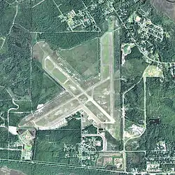
Einrichtungen
Der Flughafen umfasst ein Gebiet von 4,4 km2 und hat drei Start- und Landebahnen:[1]
- Runway 06/24: 1 607 x 46 m, Oberfläche: Beton
- Runway 13/31: 1 654 x 46 m, Oberfläche: Beton
- Runway 18/36: 1 601 x 46 m, Oberfläche: Beton
Weblinks
- Florida Aviation System Plan (FASP): Apalachicola Municipal Airport
- Flughafendaten auf World Aero Data (englisch, Stand 2006)
Einzelnachweise
- AirportIQ 5010: Apalachicola Regional - Cleve Randolph Field. GCR1.com, abgerufen am 19. Oktober 2017 (englisch).
Apalachicola | Collier County | Daytona Beach | Destin–Fort Walton | Fort Lauderdale-Hollywood | Fort Myers | Gainesville | Jacksonville (Craig) | Jacksonville (Cecil) | Jacksonville (Herlong) | Jacksonville (International) | Key West | Kissimmee | Lakeland | Miami (Executive) | Miami (Homestead) | Miami (International) | Melbourne | Opa-locka | Orlando (Executive) | Orlando (International) | Orlando (Sanford) | Palm Beach (International) | Palm Beach (Lantana) | Palm Beach (North) | Palm Beach (Pahokee) | Panama City | Pensacola | Punta Gorda | Sarasota | Sebring | St. Augustine | St. Petersburg-Clearwater | Tallahassee | Tampa (Executive) | Tampa (International) | Vero Beach
Militärisch: Eglin | Homestead | Hurlburt | MacDill | Patrick | Pensacola | St. Petersburg-Clearwater | Tyndall
Behördlich genutzt: Opa-locka | Launch and Landing Facility