Vail (Arizona)
Vail ist ein Census-designated place im Pima County im US-Bundesstaat Arizona.
| Vail | |
|---|---|
 | |
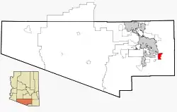
| Lage im Pima County und in Arizona | |
 | |
| Basisdaten | |
| Staat: | Vereinigte Staaten |
| Bundesstaat: | Arizona |
| County: | Pima County |
| Koordinaten: | 32° 0′ N, 110° 42′ W |
| Zeitzone: | Mountain Standard Time (UTC−7) |
| Einwohner: | 13.604 (Stand: 2020) |
| Fläche: | 47,2 km² (ca. 18 mi²) davon 47,2 km² (ca. 18 mi²) Land |
| Höhe: | 986 m |
| Postleitzahl: | 85641 |
| Vorwahl: | +1 520 |
| FIPS: | 04-78540 |
| GNIS-ID: | 0013150 |
Der Ort hat 2484 Einwohner auf einer Fläche von 47,2 km²; das entspricht einer Bevölkerungsdichte von 52,7/km².
Verkehr
Vail liegt nahe der Kreuzung zwischen dem Interstate 10 und der Arizona State Route 83
Weblinks
Commons: Vail (Arizona) – Sammlung von Bildern, Videos und Audiodateien
This article is issued from Wikipedia. The text is licensed under Creative Commons - Attribution - Sharealike. The authors of the article are listed here. Additional terms may apply for the media files, click on images to show image meta data.