Arizona State Route 83
Die Arizona State Route 83 (kurz AZ 83) ist eine State Route im US-Bundesstaat Arizona, die in Nord-Süd-Richtung verläuft.
| |
|---|---|
| Karte | |
 | |
| Basisdaten | |
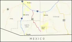
| Gesamtlänge: | 54 mi/86 km |
| Anfangspunkt: | |
| Endpunkt: | am Parker Canyon Lake |
| Countys: | Santa Cruz County Cochise County Pima County |
Die State Route beginnt am Interstate 10 nahe Vail südöstlich von Tucson und endet am Parker Canyon Lake. Bei Sonoita trifft sie auf die Arizona State Route 82. Die Straße durchquert die Countys Pima, Cochise und Santa Cruz.
Weblinks
Commons: Arizona State Route 83 – Sammlung von Bildern, Videos und Audiodateien
- Arizona Roads (englisch)
- AARoads (englisch)
This article is issued from Wikipedia. The text is licensed under Creative Commons - Attribution - Sharealike. The authors of the article are listed here. Additional terms may apply for the media files, click on images to show image meta data.