Upper East Region
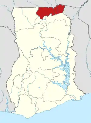
Die Upper East Region (dt. „Obere Ostregion“) ist eine Region in Ghana. Ihre Hauptstadt ist Bolgatanga.
| Upper East Region | |
|---|---|
 Karte | |
| Land | |
| Hauptstadt | Bolgatanga |
| Distriktanzahl | 15 |
| Fläche | 8.842 km² |
| Einwohnerzahl | 1.301.226 (2021) |
| Bevölkerungsdichte | 147 Ew. / km² |
| ISO 3166-2 | GH-UE |
Geografie
Die Region liegt im äußersten Nordosten des Landes und grenzt im Norden an Burkina Faso, im Osten an Togo, im Süden an die North East Region und im Westen an die Upper West Region. Die Flüsse Roter Volta und Weißer Volta fließen, von Burkina Faso kommend, von Nord nach Süd durch die Region.
Einwohnerentwicklung
| Zensusjahr | Einwohnerzahl[1][2] |
|---|---|
| 1960 | 468.638 |
| 1970 | 542.858 |
| 1984 | 772.744 |
| 2000 | 920.089 |
| 2010 | 1.046.545 |
| 2021 | 1.301.226 |
Administrative Gliederung
Die Region gliedert sich in 15 Distrikte:[3]
| Distrikt | Hauptort |
|---|---|
| Bawku Municipal | Bakwu |
| Bawku West | Zebilla |
| Binduri | Binduri |
| Bolgatanga East | Zuarugu |
| Bolgatanga Municipal | Bolgatanga |
| Bongo | Bongo |
| Builsa North Municipal | Sandema |
| Builsa South | Fumbisi |
| Garu | Garu |
| Kassena Nankana Municipal | Navrongo |
| Kassena Nankana West | Paga |
| Nabdam | Nangodi |
| Pusiga | Pusiga |
| Talensi | Tongo |
| Tempane | Tempane |
Weblinks
Commons: Upper East Region – Sammlung von Bildern, Videos und Audiodateien
- Upper East Region auf ghanadistricts.gov.gh
Einzelnachweise
- 2010 Population & Housing Census. (Nicht mehr online verfügbar.) Archiviert vom Original am 12. Juli 2018; abgerufen am 4. September 2018.
- Ghana: Verwaltungsgliederung (Regionen und Bezirke) - Einwohnerzahlen, Grafiken und Karte. Abgerufen am 21. November 2021.
- Distriktliste auf ghanadistricts.gov.gh, abgerufen am 18. Dezember 2019
This article is issued from Wikipedia. The text is licensed under Creative Commons - Attribution - Sharealike. The authors of the article are listed here. Additional terms may apply for the media files, click on images to show image meta data.