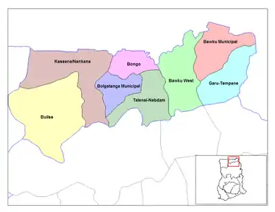
Bongo District
Der Bongo District im Nordosten Ghanas gehört zur Upper East Region. Der Distrikt hat eine gemeinsame Grenze mit dem Nachbarland Burkina Faso.
| Bongo District | |
|---|---|
 | |
| Land | |
| Region | Upper East Region |
| Hauptstadt | Bongo |
| Distriktform | Gewöhnlich |
| District Chief Executive | Francis A. Akurugu |
| Fläche | 488 km² |
| Einwohnerzahl | 77.894 (2002) |
| Bevölkerungsdichte | 160 Ew. / km² |
| ISO 3166-2 | GH-UE-BO |
Bevölkerung
Im Distrikt leben Angehörige der Ethnien der Bossi und der Frafra sprechenden Tallensi. Die Mehrheit der Bevölkerung hängt traditionellen Religionen an (53,6 %) daneben gibt es 28,3 % Christen und Anhänger des Islam (6,4 %).
Klima und Vegetation
Das Klima ist tropisch mit einer feuchten Jahreszeit von Mai bis Oktober und einer langen Trockenzeit praktisch ohne Niederschlag von Oktober bis April. Die Temperaturen bewegen sich zwischen maximal 45 °C im März/April und minimal 12 °C im Dezember. Charakteristisch ist der heiße Harmattan, der während der Trockenzeit weht.
Wirtschaft
Der Distrikt ist landwirtschaftlich geprägt.
Ortschaften im Distrikt
- Soe Soboko
- Gowrie-Tingre
- Zoko Tarongo
- Lungu
- Dua
- Namoo
- Zoko-Kodorogo
- Bongo-Nyariga
- Zoko Kanga
- Adaboya
- Bogorogo
- Gowrie Nayire Central Zoko-Gambrongo-Azaabisi
- Zoko-Gambrongo
- Seo-Asabagabisi (Wabisi)
- Vea-Akugrebisi
- Zoko-Goo
- Dua Apuwongo
- Balungu-Gantorisi.
Weblinks
Bawku Municipal | Bawku West | Binduri | Bolgatanga East | Bolgatanga Municipal | Bongo | Builsa North Municipal | Builsa South | Garu | Kassena Nankana Municipal | Kassena Nankana West | Nabdam | Pusiga | Talensi | Tempane