Thira (Gemeindebezirk)
Der Gemeindebezirk Thira (griechisch Δημοτική Ενότητα Θήρας Dimotikí Enótita Thíras) ist seit 2011 einer von zwei Gemeindebezirken der Gemeinde Thira auf der griechischen Insel Santorin. Er ging aus der ehemaligen Gemeinde hervor und gliedert sich in fünf Stadtbezirke und sieben Ortsgemeinschaften.
| Gemeindebezirk Thira Δημοτική Ενότητα Θήρας (Θήρα) | |||
|---|---|---|---|
| |||
| Basisdaten | |||
| Staat: | |||
| Region: | Südliche Ägäis
| ||
| Regionalbezirk: | Thira | ||
| Gemeinde: | Thira | ||
| Geographische Koordinaten: | 36° 24′ N, 25° 27′ O | ||
| Höhe ü. d. M.: | 567 m Ägäis–Profitis Ilias | ||
| Fläche: | 71,161 km² | ||
| Einwohner: | 14.005 (2011[1]) | ||
| Bevölkerungsdichte: | 196,8 Ew./km² | ||
| Code-Nr.: | 600101 | ||
| Gliederung: | 5 Stadtbezirke 7 Ortsgemeinschaften | ||
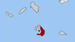
| Lage in der Gemeinde Thira und im Regionalbezirk Thira | |||
 Image:DE Thiras.svg | |||
Gliederung
Der Gemeindebezirk Thira ging im Rahmen der Verwaltungsreform 2010 aus der gleichnamigen seit 1997 bestehenden Gemeinde hervor. Diese wurde durch den Zusammenschluss von damals zwölf Landgemeinden nach der Gemeindereform gebildet.[2]
| Stadtbezirk Ortsgemeinschaft |
griechischer Name | Code | Fläche (km²) | Einwohner 2001 | Einwohner 2011 | Dörfer und Siedlungen |
|---|---|---|---|---|---|---|
| Thira | Δημοτική Κοινότητα Θήρας | 60010101 | 11,818 | 2.291 | 1.857 | Fira, Exo Gialos, Exo Katikies, Mesa Katikies, Ormos Firon, Nea Kameni, Palea Kameni, Aspronisi, Anydros, Askania, Eschati, Christiani |
| Akrotiri | Τοπική Κοινότητα Ακρωτηρίου | 60010102 | 6,849 | 450 | 489 | Akrotiri, Agios Nikolaos, Faros, Mesa Chorio |
| Vothon | Τοπική Κοινότητα Βόθωνος | 60010103 | 2,813 | 671 | 756 | Vothonas, Agia Paraskevi |
| Vourvoulos | Τοπική Κοινότητα Βουρβούλου | 60010104 | 4,122 | 475 | 535 | Vourvoulos |
| Emborio | Δημοτική Κοινότητα Εμπορείου | 60010105 | 10,962 | 2.465 | 3.085 | Emborio, Agios Georgios, Exomytis, Perissa |
| Exo Gonia | Τοπική Κοινότητα Έξω Γωνιάς | 60010106 | 3,158 | 375 | 395 | Exo Gonia, Perivolia |
| Episkopi Gonias | Δημοτική Κοινότητα Επισκοπής Γωνιάς | 60010107 | 5,113 | 1.430 | 1.462 | Episkopi Gonias, Kamari |
| Imerovigli | Τοπική Κοινότητα Ημεροβιγλίου | 60010108 | 4,366 | 503 | 535 | Imerovigli, Panagia Kalou |
| Karterados | Δημοτική Κοινότητα Καρτεράδου | 60010109 | 3,528 | 1.108 | 1.293 | Karterados, Exo Gialos |
| Megalochori | Τοπική Κοινότητα Μεγαλοχωρίου | 60010110 | 6,483 | 460 | 594 | Megalochori |
| Mesaria | Δημοτική Κοινότητα Μεσαριάς | 60010111 | 6,076 | 1.480 | 2.092 | Messaria, Monolithos |
| Pyrgos Kallistis | Τοπική Κοινότητα Πύργου Καλλίστης | 60010112 | 5,873 | 732 | 912 | Pyrgos Kallistis, Moni Profitou Iliou, Ormos Athinios |
| Gesamt | 600101 | 71,161 | 12.440 | 14.005 | ||
Einzelnachweise
- Ergebnisse der Volkszählung 2011 beim Nationalen Statistischen Dienst Griechenlands (ΕΛ.ΣΤΑΤ) (Excel-Dokument, 2,6 MB)
- Κεντρική Ένωση ∆ήµων και Κοινοτήτων Ελλάδας, Ελληνική Εταιρία Τοπικής Ανάπτυξης και Αυτοδιοίκησης (Hrsg.): Λεξικό ∆ιοικητικών Μεταβολών των ∆ήµων και Κοινοτήτων (1912–2001). 1 (Τόμος Α, α–κ). Athen 2002, ISBN 960-7509-47-1.
This article is issued from Wikipedia. The text is licensed under Creative Commons - Attribution - Sharealike. The authors of the article are listed here. Additional terms may apply for the media files, click on images to show image meta data.
