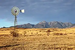
Sonoita (Arizona)
Sonoita ist ein Census-designated place im Santa Cruz County im Süden des US-Bundesstaates Arizona.
| Sonoita | |
|---|---|
 | |
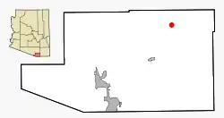
| Lage im Santa Cruz County und in Arizona | |
 | |
| Basisdaten | |
| Staat: | Vereinigte Staaten |
| Bundesstaat: | Arizona |
| County: | Santa Cruz County |
| Koordinaten: | 31° 41′ N, 110° 39′ W |
| Zeitzone: | Mountain Standard Time (UTC−7) |
| Einwohner: | 803 (Stand: 2020) |
| Fläche: | 118,1 km² (ca. 46 mi²) davon 118,1 km² (ca. 46 mi²) Land |
| Höhe: | 1489 m |
| Postleitzahl: | 85637 |
| Vorwahl: | +1 520 |
| FIPS: | 04-68220 |
| GNIS-ID: | 0034635 |
Sonoita liegt nahe der Grenze zum Pima County und ist etwa 35 Kilometer von der amerikanisch-mexikanischen Grenze entfernt. Die Gemeinde liegt nahe dem Knotenpunkt Arizona State Route 82 und Arizona State Route 83. Sonoita hat 826 Einwohner auf einer Fläche von 118,1 km². Die Bevölkerungsdichte liegt bei 7,0/km².
Weblinks
Commons: Sonoita (Arizona) – Sammlung von Bildern, Videos und Audiodateien
This article is issued from Wikipedia. The text is licensed under Creative Commons - Attribution - Sharealike. The authors of the article are listed here. Additional terms may apply for the media files, click on images to show image meta data.