Shingle Springs
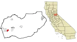
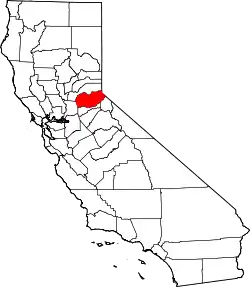
Shingle Springs ist ein Census-designated place und liegt etwa acht Kilometer südlich von Placerville (Old Hangtown), der Stadt, die die Verwaltung für den Bezirk El Dorado County im US-Bundesstaat Kalifornien innehat. Shingle Springs ist Teil der Sacramento–Arden-Arcade–Roseville-Metropolregion.
| Shingle Springs | |
|---|---|
| Spitzname: Shingle | |
 Lage in Kalifornien | |
| Basisdaten | |
| Staat: | Vereinigte Staaten |
| Bundesstaat: | Kalifornien |
| County: | El Dorado County |
| Koordinaten: | 38° 40′ N, 120° 56′ W |
| Zeitzone: | Mountain (UTC−7/−6) |
| Einwohner: | 4.660 (Stand: 2020) |
| Fläche: | 13,5 km² (ca. 5 mi²) davon 13,5 km² (ca. 5 mi²) Land |
| Postleitzahl: | 95682 |
| Vorwahl: | +1 530 |
| FIPS: | 06-71554 |
| GNIS-ID: | 1659645 |
Demografie
Nach der Zählung aus dem Jahr 2000 betrug die Einwohnerzahl 2643.
Literatur
- Durham, David L.: California's Geographic Names: A Gazetteer of Historic and Modern Names of the State. Quill Driver Books, 1998, ISBN 978-1-884995-14-9.
Weblinks
Commons: Shingle Springs – Sammlung von Bildern, Videos und Audiodateien
- Geschichte zu Shingle Springs (Seite nicht mehr abrufbar, Suche in Webarchiven)
- GNIS
This article is issued from Wikipedia. The text is licensed under Creative Commons - Attribution - Sharealike. The authors of the article are listed here. Additional terms may apply for the media files, click on images to show image meta data.
