Sant’Agata sul Santerno
Sant’Agata sul Santerno ist eine italienische Gemeinde in der Provinz Ravenna in der Region Emilia-Romagna mit 2935 Einwohnern (Stand 31. Dezember 2019).
| Sant’Agata sul Santerno | ||
|---|---|---|
 |
| |
| Staat | Italien | |
| Region | Emilia-Romagna | |
| Provinz | Ravenna (RA) | |
| Lokale Bezeichnung | Sant'Èghta | |
| Koordinaten | 44° 26′ N, 11° 52′ O | |
| Fläche | 9 km² | |
| Einwohner | 2.935 (31. Dez. 2019)[1] | |
| Postleitzahl | 48020 | |
| Vorwahl | 0545 | |
| ISTAT-Nummer | 039017 | |
| Volksbezeichnung | santagatesi | |
| Schutzpatron | Sant’Agata | |
| Website | www.comune.santagatasulsanterno.ra.it | |
Geographische Lage
Sie liegt etwa 40 km östlich von Bologna und ca. 25 km westlich von Ravenna am Fluss Santerno. Die Gemeindefläche beträgt 9,5 km² und grenzt an die Gemeinden Lugo und Massa Lombarda.
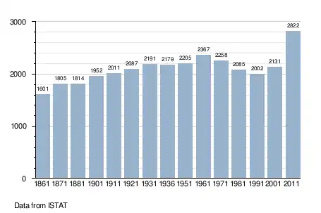
Bevölkerungsentwicklung
Weblinks
Commons: Sant’Agata sul Santerno – Sammlung von Bildern, Videos und Audiodateien
Einzelnachweise
- Statistiche demografiche ISTAT. Monatliche Bevölkerungsstatistiken des Istituto Nazionale di Statistica, Stand 31. Dezember 2019.

Gemeinden in der Provinz Ravenna in der Region Emilia-Romagna
Alfonsine | Bagnacavallo | Bagnara di Romagna | Brisighella | Casola Valsenio | Castel Bolognese | Cervia | Conselice | Cotignola | Faenza | Fusignano | Lugo | Massa Lombarda | Ravenna | Riolo Terme | Russi | Sant’Agata sul Santerno | Solarolo
This article is issued from Wikipedia. The text is licensed under Creative Commons - Attribution - Sharealike. The authors of the article are listed here. Additional terms may apply for the media files, click on images to show image meta data.