Saint-Pardoux (Haute-Vienne)
Saint-Pardoux, okzitanisch Sent Perdos, ist eine Commune déléguée in der französischen Gemeinde Saint-Pardoux-le-Lac mit 620 Einwohnern (Stand 1. Januar 2019). Saint-Pardoux liegt in der Region Nouvelle-Aquitaine, im Département Haute-Vienne, im Arrondissement Bellac.
| Saint-Pardoux | ||
|---|---|---|
.svg.png.webp)
|
| |
| Gemeinde | Saint-Pardoux-le-Lac | |
| Region | Nouvelle-Aquitaine | |
| Département | Haute-Vienne | |
| Arrondissement | Bellac | |
| Koordinaten | 46° 4′ N, 1° 17′ O | |
| Postleitzahl | 87250 | |
| Ehemaliger INSEE-Code | 87173 | |
| Eingemeindung | 1. Januar 2019 | |
| Status | Commune déléguée | |
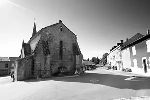 Kirche Saint-Pardoux | ||

Durch Saint-Pardoux führt die Autoroute A20.
Zur Commune déléguée gehören die Weiler Champcommunal, Chantot, Châtenet-Colon, Chéz Bejas, Fougerolles, Fréaudour, La Brandouille, La Gorce, La Ribière, La Tour, Les Cerisières, Le Chataignol, La Chatin, Le Coux, Les Grands Magneux, Le Parc, Le Puy Châtelard, Mazernaut, Montégut, Puy Bison, Puy Jouard, Puy Perrier, Vauguenige und Villarcoin.
.JPG.webp)
Die Gemeinde Saint-Pardoux wurde am 1. Januar 2019 mit Roussac und Saint-Symphorien-sur-Couze zur Commune nouvelle Saint-Pardoux-le-Lac zusammengeschlossen. Sie hat seither den Status einer Commune déléguée. Die Gemeinde Saint-Pardoux gehörte zum Kanton Ambazac. Sie grenzte im Norden an Châteauponsac, im Nordosten an Bessines-sur-Gartempe, im Südosten an Razès, im Süden an Compreignac und im Westen an Saint-Symphorien-sur-Couze.
Bevölkerungsentwicklung
| Jahr | 1962 | 1968 | 1975 | 1982 | 1990 | 1999 | 2008 | 2013 |
|---|---|---|---|---|---|---|---|---|
| Einwohner | 711 | 633 | 497 | 465 | 482 | 466 | 526 | 575 |