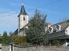
Saint-Bauld
Saint-Bauld ist eine ehemalige französische Gemeinde im Département Indre-et-Loire in der Region Centre-Val de Loire mit zuletzt 192 Einwohnern (Stand 1. Januar 2019). Sie gehörte zum Arrondissement Loches und zum Kanton Loches.
| Saint-Bauld | ||
|---|---|---|
| ||
| Region | Centre-Val de Loire | |
| Département | Indre-et-Loire | |
| Arrondissement | Loches | |
| Koordinaten | 47° 11′ N, 0° 50′ O | |
| Postleitzahl | 37310 | |
| Ehemaliger INSEE-Code | 37209 | |
| Eingemeindung | 1. Januar 2018 | |
| Status | Commune déléguée | |
Zum 1. Januar 2018 wurden Saint-Bauld und Tauxigny zur commune nouvelle Tauxigny-Saint-Bauld zusammengeschlossen. Lediglich Saint-Bauld ist eine commune déléguée innerhalb der neuen Gemeinde. Das Verwaltungszentrum befindet sich im Ort Tauxigny.[1]
Geographie
Saint-Bauld liegt etwa 26 Kilometer südsüdöstlich von Tours am Échandon, einem Nebenfluss der Indre.
Bevölkerungsentwicklung
| 1962 | 1968 | 1975 | 1982 | 1990 | 1999 | 2006 | 2013 |
|---|---|---|---|---|---|---|---|
| 174 | 173 | 132 | 115 | 159 | 167 | 191 | 197 |
| Quellen: Cassini und INSEE | |||||||
Sehenswürdigkeiten
- Kirche Saint-Bauld
- Schloss Fontenay-Isoré aus dem 15. Jahrhundert

Kirche Saint-Bauld
Literatur
- Le Patrimoine des Communes d’Indre-et-Loire. Flohic Editions, Band 2, Paris 2001, ISBN 2-84234-115-5, S. 851–853.
Einzelnachweise
- Louis Le Franc: Recueil des actes administratifs n°37-2017-09012. (pdf) Arrêté préfectoral n° 17-34 portant création de la commune nouvelle Tauxigny-Saint-Bauld. 11. September 2017, S. 102-106, abgerufen am 19. Januar 2018 (französisch).
Weblinks
Commons: Saint-Bauld – Sammlung von Bildern, Videos und Audiodateien
This article is issued from Wikipedia. The text is licensed under Creative Commons - Attribution - Sharealike. The authors of the article are listed here. Additional terms may apply for the media files, click on images to show image meta data.
