Ramganga
Die Ramganga (Hindi रामगंगा Rāmgaṅgā) ist ein etwa 560 km langer, linker Nebenfluss des Ganges in Indien.
| Ramganga | ||
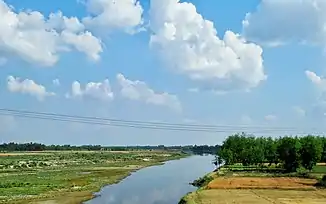
 Ramganga nahe Moradabad Ramganga nahe Moradabad | ||
| Daten | ||
| Lage | Uttarakhand, Uttar Pradesh (Indien) | |
| Flusssystem | Ganges | |
| Abfluss über | Ganges → Indischer Ozean | |
| Quelle | in der Region Kumaon im Himalaya 30° 5′ 48″ N, 79° 15′ 26″ O | |
| Quellhöhe | ca. 2200 m | |
| Mündung | 80 km oberhalb von Kanpur in den Ganges 27° 10′ 42″ N, 79° 50′ 50″ O | |
| Mündungshöhe | 130 m | |
| Höhenunterschied | ca. 2070 m | |
| Sohlgefälle | ca. 3,7 ‰ | |
| Länge | 560 km | |
| Einzugsgebiet | 30.641 km² | |
| Linke Nebenflüsse | Naurad, Kosi | |
| Rechte Nebenflüsse | Khoh | |
| Durchflossene Stauseen | Ramganga-Talsperre | |
| Großstädte | Bareli, Muradabad | |
Sein Quellgebiet liegt in der Region Kumaon, am Fuße des westlichen Himalayas. Die Ramganga durchfließt den Corbett-Nationalpark, Indiens ältester Nationalpark, und mündet 80 km oberhalb von Kanpur in den Ganges.
This article is issued from Wikipedia. The text is licensed under Creative Commons - Attribution - Sharealike. The authors of the article are listed here. Additional terms may apply for the media files, click on images to show image meta data.