Provinzen von Simbabwe
Simbabwe ist in zehn Provinzen unterteilt, von denen zwei als Metropolprovinzen („metropolitan provinces“) bezeichnet werden.[1]
| Name | Verwaltungs- sitz |
Einwohner (2012)[2] |
Fläche (km²)[3] |
Bevölkerungs- dichte (Ew./km²)[2] |
Karte |
|---|---|---|---|---|---|
| Provinz Bulawayo | Bulawayo | 653.337 | 479 | 1369 | .svg.png.webp) |
| Provinz Harare | Harare | 2.123.132 | 872 | 2406 | .svg.png.webp) |
| Provinz Manicaland | Mutare | 1.752.698 | 36.459 | 48 | .svg.png.webp) |
| Provinz Mashonaland Central | Bindura | 1.152.520 | 28.347 | 40 | .svg.png.webp) |
| Provinz Mashonaland East | Marondera | 1.344.955 | 32.230 | 41 | .svg.png.webp) |
| Provinz Mashonaland West | Chinhoyi | 1.501.656 | 57.441 | 25 | .svg.png.webp) |
| Provinz Masvingo | Masvingo | 1.485.090 | 56.566 | 26 | .svg.png.webp) |
| Provinz Matabeleland North | Lupane | 749.017 | 75.025 | 13 | .svg.png.webp) |
| Provinz Matabeleland South | Gwanda | 683.893 | 54.172 | 10 | .svg.png.webp) |
| Provinz Midlands | Gweru | 1.614.941 | 49.166 | 33 | .svg.png.webp) |
| Simbabwe gesamt | Harare | 13.061.239 | 390.757 | 33 |
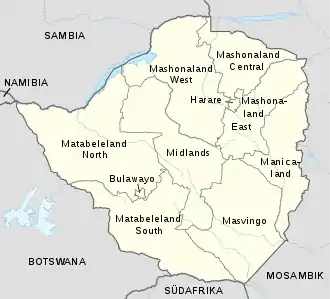
Provinzen Simbabwes
Einzelnachweise
- Provinces. In: Official Government of Zimbabwe Web Portal. Abgerufen am 9. April 2021.
- Census 2012 Report – ZIMBABWE POPULATION CENSUS 2012. (Nicht mehr online verfügbar.) Population Census Office, archiviert vom Original am 10. Januar 2017; abgerufen am 7. August 2018 (englisch). Info: Der Archivlink wurde automatisch eingesetzt und noch nicht geprüft. Bitte prüfe Original- und Archivlink gemäß Anleitung und entferne dann diesen Hinweis.
- Census 2012 – Preliminary Report. Nationale Statistikbehörde Simbabwes, abgerufen am 7. August 2018 (englisch).
This article is issued from Wikipedia. The text is licensed under Creative Commons - Attribution - Sharealike. The authors of the article are listed here. Additional terms may apply for the media files, click on images to show image meta data.