Port Macquarie-Hastings Council
Port Macquarie-Hastings ist ein lokales Verwaltungsgebiet (LGA) im australischen Bundesstaat New South Wales. Das Gebiet ist 3.683,0 km² groß und hat etwa 78.500 Einwohner.[1]
| Port Macquarie-Hastings | |
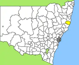 Lage des Port Macquarie-Hastings Council in New South Wales | |
| Gliederung | |
| Staat: | |
| Bundesstaat: | |
| Verwaltungssitz: | Port Macquarie |
| Daten und Zahlen | |
| Fläche: | 3.683,0 km² |
| Einwohner: | 78.539 (2016) [1] |
| Bevölkerungsdichte: | 21 Einwohner je km² |
Port Macquarie-Hastings liegt an der Ostküste in der Mid-North-Coast-Region des Staates 390 km nordöstlich der Metropole Sydney und 560 km südlich von Brisbane. Das Gebiet umfasst 116 Ortsteile und Ortschaften, darunter Bellangry, Birdwood, Bonny Hills, Byabarra, Camden Haven, Comboyne, Ellenborough, North Haven, West Haven, Dunbogan, Gannons Creek, Herons Creek, Kendall, Kew, Kindee, Lake Cathie, Lakewood, Laurieton, Long Flat, Lorne, Mortons Creek, Pappinbarra, Pembrooke, Port Macquarie, Rollands Plains, Telegraph Point, Wauchope und Yarras. Der Verwaltungssitz des Councils befindet sich in der Hafenstadt Port Macquarie, wo etwa 44.800 Einwohner leben.[2]
Verwaltung
Der Council von Port Macquarie-Hastings hat neun Mitglieder. Acht Councillor und der Ratsvorsitzende und Mayor (Bürgermeister) werden direkt von allen Bewohnern der LGA gewählt. Port Macquarie-Hastings ist nicht in Bezirke untergliedert.
Weblinks
Einzelnachweise
- Australian Bureau of Statistics: Port Macquarie-Hastings (A) (Englisch) In: 2016 Census QuickStats. 27. Juni 2017. Abgerufen am 12. Mai 2020.
- Australian Bureau of Statistics: Port Macquarie (Englisch) In: 2016 Census QuickStats. 27. Juni 2017. Abgerufen am 12. Mai 2020.