Pima (Arizona)
Pima ist ein Ort im Graham County im US-Bundesstaat Arizona. Er hat 1989 Einwohner auf einer Fläche von 6,6 km². Die Bevölkerungsdichte liegt bei 303,5/km². Pima liegt am Gila River. Es ist benannt nach dem Indianerstamm Pima. Durch den Ort verläuft der U.S. Highway 70.
| Pima | |
|---|---|
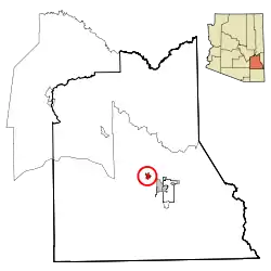 Lage im County und in Arizona | |
| Basisdaten | |
| Gründung: | 1879 |
| Staat: | Vereinigte Staaten |
| Bundesstaat: | Arizona |
| County: | Graham County |
| Koordinaten: | 32° 53′ N, 109° 50′ W |
| Zeitzone: | Mountain Standard Time (UTC−7) |
| Einwohner: | 2.847 (Stand: 2020) |
| Fläche: | 6,6 km² (ca. 3 mi²) davon 6,5 km² (ca. 3 mi²) Land |
| Höhe: | 865 m |
| Postleitzahlen: | 85535, 85543 |
| Vorwahl: | +1 928 |
| FIPS: | 04-55560 |
| GNIS-ID: | 0009433 |
| Website: | www.pimatown.az.gov |
Nahe gelegene Parks und Erholungsgebiete sind Coronado National Forest und Hot Wells Dunes.
This article is issued from Wikipedia. The text is licensed under Creative Commons - Attribution - Sharealike. The authors of the article are listed here. Additional terms may apply for the media files, click on images to show image meta data.