Paugnut State Forest
Paugnut State Forest ist ein State Forest im US-Bundesstaat Connecticut auf dem Gebiet der Gemeinden Torrington und Winchester.[4] Die Verwaltungsgebäude des Forsts im Stil des Arts and Crafts wurden 1937 vom Civilian Conservation Corps erbaut und liegen im heutigen Burr Pond State Park.[5] Das Paugnut Forest Administration Building wurde am 5. September 1986 in das National Register of Historic Places eingetragen.[6][7] Weitere historische Spuren sind die Fundamente der Kondensmilch-Fabrik von Gail Borden am Burr Pond. Sie stammen aus dem Jahr 1857.[8][9]
Paugnut State Forest | ||
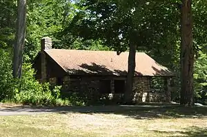 Verwaltungsgebäude Paugnut State Forest (2016) Verwaltungsgebäude Paugnut State Forest (2016) | ||
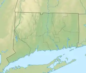
| Lage | Torrington, Winchester, Litchfield County, USA[1] | |
| Fläche | 6,65 km2[2] | |
| Geographische Lage | 41° 51′ N, 73° 6′ W | |
| ||
| Einrichtungsdatum | 1929[3] | |
| Verwaltung | Dept. of Energy & Environmental Protection, Connecticut State | |
Geographie
Der Forst liegt auf den Höhen über dem Tal des Still River, der von Südwesten nach Nordosten fließt und in den Farmington River mündet. Der Walnut Mountain mit 1310 ft (402 m) über dem Meer ist die Höchste Erhebung.[10]
Freizeitaktivitäten
Der Forst wird von mehreren Wanderwegen durchzogen. Der John Muir Trail verbindet den Burr Pond State Park und den Sunnybrook State Park, die, jeweils nördlich bzw. südlich, direkt an den Forst angrenzen.[11]
Siehe auch
Einzelnachweise
- Geographic Names Information System. United States Geological Survey.
- State Parks and Forests: Finanzierung, Mitarbeitergewinnung und Empfehlungen. (PDF)
- Connecticut State Forests Seedling Letterbox Series - Clues for Paugnut State Forest. In: State Parks and Forests. Connecticut Department of Energy and Environmental Protection. Abgerufen am 30. September 2013.
- Paugnut State Forest. In: State Parks and Forests. Connecticut Department of Energy and Environmental Protection. Abgerufen am 30. September 2013.
- Connecticut Historical Commission: Historic Resources Inventory Form. National Park Service. 21. August 1986. Abgerufen am 23. Juni 2015.
- Paugnut Forest Administration Building im National Register Information System. National Park Service, abgerufen am 1. August 2017.
- [http://focus.nps.gov/pdfhost/docs/NRHP/Text/64000087.pdf National Register of Historic Places Registration Form]. National Park Service. 5. September 1986. Abgerufen am 23. Juni 2015.
- World’s First Condensed Milk Factory. The Historical Marker Database. Abgerufen am 23. Juni 2015.
- Burr Pond State Park. In: State Parks and Forests. Connecticut Department of Energy and Environmental Protection. Abgerufen am 23. Juni 2015.
- U.S. Geological Survey. The National Map
- Paugnut State Forest: John Muir Trail. Connecticut Bureau of Outdoor Recreation, State Parks Division. 2008. Abgerufen am 23. Juni 2015.
Weblinks
- Paugnut State Forest Connecticut Department of Energy and Environmental Protection
- Paugnut State Forest Map Connecticut Department of Energy and Environmental Protection
- Stateparks.com
- Thehour.com
- ConnecticutAtoZ
- ohranger.com