Mid Murray Council
Der Mid Murray Council ist ein lokales Verwaltungsgebiet (LGA) im australischen Bundesstaat South Australia. Das Gebiet ist 7.957 km² groß und hat etwa 8600 Einwohner (2016).
| Mid Murray Council | |
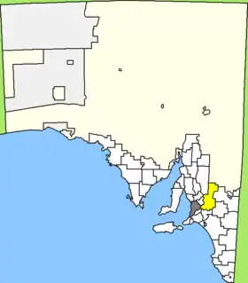 Lage des Mid Murray Council in South Australia | |
| Gliederung | |
| Staat: | |
| Bundesstaat: | |
| Verwaltungssitz: | Mannum |
| Daten und Zahlen | |
| Fläche: | 7.957 km² |
| Einwohner: | 8.642 (2016) [1] |
| Bevölkerungsdichte: | 1,1 Einwohner je km² |
| Wards: | 5 |
Mid Murray liegt entlang des Murray River etwa 60 km östlich der Metropole Adelaide. Das Gebiet beinhaltet 128 Ortsteile und Ortschaften: Angas, Angas Valley, Anna, Annadale, Apamurra, Arnold Park, Bagot, Baseby Reserve, Beatty, Beaumont Sub Division, Big Bend, Black Hill, Blanchetown, Bolto Reserve, Bonython, Bower, Bowhill, Brenda Park, Brownlow, Bryants Creek, Bulls Tree Landing, Burdett, Cadell, Caloote, Caloote Highland, Caloote Landing Reserve, Cambrai, Caurnamont, Claypans, Coolcha, Cosy Corner, Cowirra, Cross Roads, Dutton, Eba, Fidges Reserve, Finniss, Fisher, Five Mile, Florieton, Forster, Frahns Shack, Freeman's Landing, Greenways Landing, Hay, Haylands, Hayville, Hogwash Bend, Idyll Acres, Jellicoe, Julanker Shacks, Jutland, Keyneton, Kongolia, Kroehns Landing, Lake Carlet, Langs Landing, Lindley, Mannum, Marks Landing, Mary Ann Reserve, Maude, Maynards Landing, McBeans Pound, Milendella, Morgan, Morphett Flat, Mount Mary, Murbko, Neeta Irrigation Area, New Era, Nildottie, No.2 Pumping Shed, Noa No Reserve, North Neeta Reserve, North West Bend, North West Bend, Pellaring Flat, Palmer, Pelican Point, Peppers Shacks, Pipeline Subdivision, Pine Village, Pompoota, Ponde, Punthari, Punyelroo, Purnong, Purnong Landing, Randell, Reedy Creek, Ridley, River Cove Estate, Riverbanks Estate, Rockleigh, Rocky Point, Roonka, Salisbury Shacks, Sanderston, Sandleton, Schmidt's Shacks, Scotts Creek, Scrubby Flat, Sedan, Seven Mile, Shack Site Reserve, Skurray, South Punyelroo, Stonefield, Stuart, Summerfield, Swan Reach, Teal Flat, Tepko, The Gums, Thiele's Shacks, Towitta, Truro, Tungkillo, Walker Flat, Wall Flat, Waterfalls Reserve, Weston Flat, Wombat Rest, Wongulla, Younghusband, Younghusband Holdings und Zadow Landing. Der Verwaltungssitz des Councils befindet sich in Mannum am Murray im Süden der LGA, wo etwa 2400 Einwohner leben (2016).[2]
Verwaltung
Der Council von Mid Murray hat elf Mitglieder, zehn Councillor werden von den Bewohnern der fünf Wards gewählt (drei aus Randall Ward, je zwei aus River North, River South und Sturt Ward und einer aus Reedy Creek Ward). Diese fünf Bezirke sind unabhängig von den Ortschaften festgelegt. Der Ratsvorsitzende und Mayor (Bürgermeister) wird zusätzlich von allen Bewohnern der LGA gewählt.
Weblinks
- Website des Mid Murray Council (englisch)
Einzelnachweise
- Australian Bureau of Statistics: Mid Murray (DC) (Local Government Area) (Englisch) In: 2016 Census QuickStats. 27. Juni 2017. Abgerufen am 20. April 2020.
- Australian Bureau of Statistics: Mannum (Urban Centre/Locality) (Englisch) In: 2016 Census QuickStats. 27. Juni 2017. Abgerufen am 20. April 2020.