Martinchel
Martinchel ist eine Gemeinde (Freguesia) in Portugal.
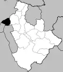
Lage von Fontes im Kreis
| Martinchel | ||||||
|---|---|---|---|---|---|---|
| ||||||
| Basisdaten | ||||||
| Region: | Centro | |||||
| Unterregion: | Médio Tejo | |||||
| Distrikt: | Santarém | |||||
| Concelho: | Abrantes | |||||
| Koordinaten: | 39° 32′ N, 8° 19′ W | |||||
| Einwohner: | 604 (Stand: 30. Juni 2011)[1] | |||||
| Fläche: | 17,07 km² (Stand: 1. Januar 2010)[2] | |||||
| Bevölkerungsdichte: | 35 Einwohner pro km² | |||||
| Politik | ||||||
| Adresse der Gemeindeverwaltung: | Junta de Freguesia de Martinchel Largo do Rossio, nº 28 2200-638 Martinchel | |||||
Martinchel gehört zum Kreis Abrantes im Distrikt Santarém, besitzt eine Fläche von 17,1 km² und hat 604 Einwohner (Stand 30. Juni 2011)[1].
Bauwerke
Einzelnachweise
- www.ine.pt – Indikator Resident population by Place of residence and Sex; Decennial in der Datenbank des Instituto Nacional de Estatística
- Übersicht über Code-Zuordnungen von Freguesias auf epp.eurostat.ec.europa.eu
Weblinks
- Karte der Freguesia Martinchel beim Instituto Geográfico do Exército
Freguesias im Concelho Abrantes
Abrantes (São Vicente e São João) e Alferrarede | Aldeia do Mato e Souto | Alvega e Concavada | Bemposta | Carvalhal | Fontes | Martinchel | Mouriscas | Pego | Rio de Moinhos | São Facundo e Vale de Mós | São Miguel do Rio Torto e Rossio ao Sul do Tejo | Tramagal
This article is issued from Wikipedia. The text is licensed under Creative Commons - Attribution - Sharealike. The authors of the article are listed here. Additional terms may apply for the media files, click on images to show image meta data.