Loiron
Loiron ist eine Ortschaft und eine Commune déléguée in der französischen Gemeinde Loiron-Ruillé mit 1.740 Einwohnern (Stand: 1. Januar 2019) im Département Mayenne in der Region Pays de la Loire. Die Einwohner werden Loironnais genannt.
| Loiron | ||
|---|---|---|

|
| |
| Gemeinde | Loiron-Ruillé | |
| Region | Pays de la Loire | |
| Département | Mayenne | |
| Arrondissement | Laval | |
| Koordinaten | 48° 4′ N, 0° 56′ W | |
| Postleitzahl | 53320 | |
| Ehemaliger INSEE-Code | 53137 | |
| Eingemeindung | 1. Januar 2016 | |
| Status | Commune déléguée | |
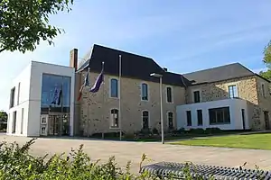 ehemaliges Rathaus (Mairie) von Loiron | ||

Die Gemeinde Loiron wurde am 1. Januar 2016 mit Ruillé-le-Gravelais zur Commune nouvelle Loiron-Ruillé zusammengeschlossen. Sie gehörte zum Arrondissement Laval und zum Kanton Loiron.
Geografie
Loiron liegt etwa 16 Kilometer westsüdwestlich von Laval.
Bevölkerungsentwicklung
| 1962 | 1968 | 1975 | 1982 | 1990 | 1999 | 2006 | 2013 |
|---|---|---|---|---|---|---|---|
| 822 | 782 | 965 | 1236 | 1240 | 1273 | 1449 | 1539 |
| Quellen: Cassini und INSEE | |||||||
Sehenswürdigkeiten
- Kirche Saint-Gervais-Saint-Protais
- Kapelle von La Charbonnière
.JPG.webp)
Kirche St-Gervais-St-Protais
Literatur
- Le Patrimoine des Communes de la Mayenne. Flohic Editions, Band 2, Paris 2002, ISBN 2-84234-135-X, S. 656–658.
Weblinks
Commons: Loiron – Sammlung von Bildern, Videos und Audiodateien
This article is issued from Wikipedia. The text is licensed under Creative Commons - Attribution - Sharealike. The authors of the article are listed here. Additional terms may apply for the media files, click on images to show image meta data.