Liste der Municipios in Morelos
Der mexikanische Bundesstaat Morelos ist in 36 Verwaltungsbezirke (Municipios) unterteilt. Die Verwaltungsbezirke werden aus 1.578 Ortschaften (span. Localidades) (davon 98 urbane = städtische) gebildet. Zu den ländlichen Gemeinden (Pueblos) zählen ebenso Farmen (Ranchos, Haziendas) und andere alleinstehende Gebäude (Mühlen, Poststationen, Tankstellen usw.). Die Zahl der Ortschaften ist in den letzten Jahren ansteigend (2000: 1.341; 2010: 1.504).
| Schlüs- sel |
Municipio | Verwaltungssitz (Cabecera Municipal) |
Fläche [km²] |
Einwohnerzahl[1] | Bevöl- kerungs- dichte [Ew. pro km²] |
Anzahl der Orte (Localidades) | ||
|---|---|---|---|---|---|---|---|---|
| 2000[2] | 2010[3] | 2020[4] | ||||||
| 001 | Amacuzac | Amacuzac | 117,24 | 16.482 | 17.021 | 17.598 | 150,1 | 31 |
| 002 | Atlatlahucan | Atlatlahucan | 79,37 | 14.708 | 18.895 | 25.232 | 317,9 | 41 |
| 003 | Axochiapan | Axochiapan | 141,51 | 30.436 | 33.695 | 39.174 | 276,8 | 58 |
| 004 | Ayala | Ciudad Ayala | 368,34 | 69.381 | 78.866 | 89.834 | 243,9 | 131 |
| 005 | Coatlán del Río | Coatlán del Río | 83,40 | 9.356 | 9.471 | 10.520 | 126,1 | 19 |
| 006 | Cuautla | Cuautla | 121,88 | 153.329 | 175.207 | 187.118 | 1.535,3 | 64 |
| 007 | Cuernavaca | Cuernavaca | 199,71 | 338.706 | 365.168 | 378.476 | 1.895,1 | 62 |
| 008 | Emiliano Zapata | Emiliano Zapata | 68,26 | 57.617 | 83.485 | 107.053 | 1.568,3 | 31 |
| 009 | Huitzilac | Huitzilac | 189,11 | 15.184 | 17.340 | 24.515 | 129,6 | 69 |
| 010 | Jantetelco | Jantetelco | 102,27 | 13.745 | 15.646 | 18.402 | 179,9 | 42 |
| 011 | Jiutepec | Jiutepec | 55,93 | 170.589 | 196.953 | 215.357 | 3.850,5 | 26 |
| 012 | Jojutla | Jojutla | 149,01 | 53.351 | 55.115 | 57.682 | 387,1 | 74 |
| 013 | Jonacatepec de Leandro Valle |
Jonacatepec de Leandro Valle |
90,33 | 13.623 | 14.604 | 16.694 | 184,8 | 26 |
| 014 | Mazatepec | Mazatepec | 57,91 | 8.821 | 9.456 | 9.653 | 166,7 | 22 |
| 015 | Miacatlán | Miacatlán | 162,62 | 23.984 | 24.990 | 15.802 | 97,2 | 29 |
| 016 | Ocuituco | Ocuituco | 86,55 | 15.090 | 16.858 | 19.219 | 222,1 | 36 |
| 017 | Puente de Ixtla | Puente de Ixtla | 237,21 | 54.149 | 61.585 | 40.018 | 168,7 | 59 |
| 018 | Temixco | Temixco | 102,76 | 92.850 | 108.126 | 122.263 | 1.189,8 | 39 |
| 019 | Tepalcingo | Tepalcingo | 368,64 | 24.133 | 25.346 | 28.122 | 76,3 | 42 |
| 020 | Tepoztlán | Tepoztlán | 242,39 | 32.921 | 41.629 | 54.987 | 226,9 | 72 |
| 021 | Tetecala | Tetecala | 67,68 | 6.917 | 7.441 | 7.617 | 112,5 | 17 |
| 022 | Tetela del Volcán | Tetela del Volcán | 79,29 | 16.428 | 19.138 | 14.853 | 187,3 | 21 |
| 023 | Tlalnepantla | Tlalnepantla | 107,86 | 5.626 | 6.636 | 7.943 | 73,6 | 13 |
| 024 | Tlaltizapán | Tlaltizapán | 238,46 | 45.272 | 48.881 | 52.399 | 219,7 | 77 |
| 025 | Tlaquiltenango | Tlaquiltenango | 543,94 | 30.017 | 31.534 | 33.789 | 62,1 | 46 |
| 026 | Tlayacapan | Tlayacapan | 57,20 | 13.851 | 16.543 | 19.408 | 339,3 | 47 |
| 027 | Totolapan | Totolapan | 59,98 | 8.742 | 10.789 | 12.750 | 212,6 | 29 |
| 028 | Xochitepec | Xochitepec | 93,23 | 45.643 | 63.382 | 73.539 | 788,8 | 84 |
| 029 | Yautepec | Yautepec de Zaragoza | 179,60 | 84.405 | 97.827 | 105.780 | 589,00 | 100 |
| 030 | Yecapixtla | Yecapixtla | 173,21 | 36.582 | 46.809 | 56.083 | 323,8 | 62 |
| 031 | Zacatepec | Zacatepec de Hidalgo | 30,75 | 33.331 | 35.063 | 36.094 | 1173,8 | 21 |
| 032 | Zacualpan de Amilpas | Zacualpan de Amilpas | 53,76 | 7.962 | 9.087 | 9.965 | 185,4 | 16 |
| 033 | Temoac | Temoac | 37,09 | 12.065 | 14.641 | 16.574 | 446,9 | 16 |
| 034 | Coatetelco | Coatetelco | 51,55 | – | 11.347 | 220,1 | 14 | |
| 035 | Xoxocotla | Xoxocotla | 61,67 | – | 27.805 | 450,9 | 28 | |
| 036 | Hueyapan | Hueyapan | 19,18 | – | 7.855 | 409,5 | 14 | |
| 17 Estado de Morelos | Cuernavaca | 4.878,90 | 1.555.296 | 1.777.227 | 1.971.520 | 404,1 | 36 | |
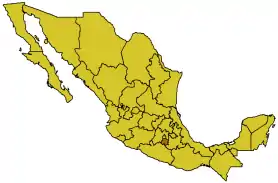
Karte Mexikos (Morelos hervorgehoben)
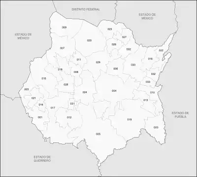
Municipios in Morelos
Einzelnachweise
Weblinks
- Offizielles Portal zu allen Municipios von Morelos (spanisch)
- Enciclopedia de los Municipios y Delegaciones de México: Morelos (spanisch)
This article is issued from Wikipedia. The text is licensed under Creative Commons - Attribution - Sharealike. The authors of the article are listed here. Additional terms may apply for the media files, click on images to show image meta data.