Liste der Einträge im National Register of Historic Places in New Bedford (Massachusetts)
Die Liste der Einträge im National Register of Historic Places in New Bedford in Massachusetts führt alle Bauwerke, National Historic Landmarks und historischen Stätten in New Bedford auf, die in das National Register of Historic Places aufgenommen wurden.
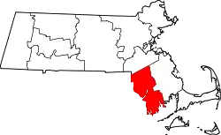
Die vorliegende Liste wurde aufgrund der Vielzahl an Einträgen in New Bedford ausgelagert und ist integraler Bestandteil der Liste der Einträge im National Register of Historic Places im Bristol County.[1]
Legende
| NRHP | Historic Place |
|---|---|
| NHL | Historic Landmark |
| NHLD | Historic Landmark District |
| HD | Historic District |
Aktuelle Einträge
| [2] | Name[3] | Bild | Eintragsdatum | Lage | Ort | Beschreibung |
|---|---|---|---|---|---|---|
| 1 | Acushnet Heights Historic District |  Acushnet Heights Historic District |
1. Dez. 1989 ID-Nr. 89002035 |
41° 38′ 52″ N, 70° 55′ 53″ W |
New Bedford | |
| 2 | Butler Flats Light | 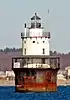 Butler Flats Light |
15. Juni 1987 ID-Nr. 87001530 |
New Bedford Channel 41° 36′ 7″ N, 70° 53′ 54″ W |
New Bedford | |
| 3 | Buttonwood Park Historic District | 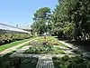 Buttonwood Park Historic District |
24. Aug. 2000 ID-Nr. 00000915 |
Kempton St., Rockdale Ave., Hawthorne St. und Brownell Ave. 41° 37′ 55″ N, 70° 57′ 7″ W |
New Bedford | |
| 4 | Sgt. William H. Carney House | 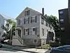 Sgt. William H. Carney House |
21. Apr. 1975 ID-Nr. 75000243 |
128 Mill St. 41° 38′ 15″ N, 70° 55′ 59″ W |
New Bedford | |
| 5 | Central New Bedford Historic District | 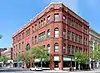 Central New Bedford Historic District weitere Bilder |
24. Apr. 1980 ID-Nr. 80000430 |
41° 38′ 6″ N, 70° 55′ 39″ W |
New Bedford | |
| 6 | County Street Historic District |  County Street Historic District |
11. Aug. 1976 ID-Nr. 76000229 |
41° 37′ 55″ N, 70° 55′ 55″ W |
New Bedford | |
| 7 | Dawson Building | 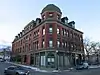 Dawson Building |
30. Sep. 1982 ID-Nr. 82001900 |
1851 Purchase St. 41° 39′ 0″ N, 70° 55′ 48″ W |
New Bedford | |
| 8 | Thomas Donaghy School |  Thomas Donaghy School |
2. März 1989 ID-Nr. 89000041 |
68 South St. 41° 37′ 33″ N, 70° 55′ 25″ W |
New Bedford | |
| 9 | Ernestina (schooner) | 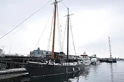 Ernestina (schooner) weitere Bilder |
3. Jan. 1985 ID-Nr. 85000022 |
Steamship Wharf 41° 38′ 1″ N, 70° 55′ 16″ W |
New Bedford | |
| 10 | Fire Station No. 4 | 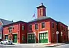 Fire Station No. 4 |
24. Juli 1975 ID-Nr. 75000250 |
79 S. 6th St. 41° 37′ 41″ N, 70° 55′ 38″ W |
New Bedford | Heute Standort des New Bedford Fire Museum. |
| 11 | First Baptist Church | 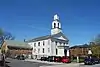 First Baptist Church |
21. Apr. 1975 ID-Nr. 75000251 |
149 William St. 41° 38′ 6″ N, 70° 55′ 44″ W |
New Bedford | |
| 12 | Fort Taber District | 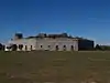 Fort Taber District |
8. Feb. 1973 ID-Nr. 73001954 |
41° 35′ 36″ N, 70° 54′ 14″ W |
New Bedford | |
| 13 | Griffin Street Cemetery |  Griffin Street Cemetery |
19. März 2014 ID-Nr. 14000062 |
S. 2nd & Griffin Sts. 41° 37′ 42″ N, 70° 55′ 21,9″ W |
New Bedford | |
| 14 | Hazelwood Park |  Hazelwood Park |
24. Juni 2010 ID-Nr. 10000389 |
597-603 Brock Ave. 41° 36′ 24″ N, 70° 54′ 48″ W |
New Bedford | |
| 15 | Head of the River Historic District |  Head of the River Historic District |
2. Dez. 2009 ID-Nr. 09000965 |
2-28 Mill Rd., 2-13 Tarkiln Hill Rd. 41° 40′ 54,2″ N, 70° 55′ 9,1″ W |
New Bedford | Erstreckt sich bis auf das Stadtgebiet von Acushnet. |
| 16 | Hotel Waverly | 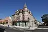 Hotel Waverly |
26. Jan. 1990 ID-Nr. 89002326 |
1162-1166 Acushnet Ave. 41° 39′ 26″ N, 70° 55′ 38″ W |
New Bedford | |
| 17 | Howland Mill Village Historic District | 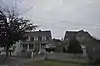 Howland Mill Village Historic District |
30. Mai 1996 ID-Nr. 96000609 |
41° 36′ 58″ N, 70° 56′ 0″ W |
New Bedford | |
| 18 | Robert C. Ingraham School |  Robert C. Ingraham School |
2. März 2010 ID-Nr. 10000056 |
80 Rivet St. 41° 37′ 14,2″ N, 70° 55′ 20,3″ W |
New Bedford | |
| 19 | Jewish Cemetery |  Jewish Cemetery |
15. Apr. 2014 ID-Nr. 14000155 |
Old Plainville Road 41° 40′ 50,9″ N, 70° 58′ 1,2″ W |
New Bedford | |
| 20 | Nathan and Mary Johnson Properties | 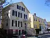 Nathan and Mary Johnson Properties |
16. Feb. 2000 ID-Nr. 00000260 |
41° 37′ 59″ N, 70° 55′ 44″ W |
New Bedford | Standort der Underground Railroad |
| 21 | Lightship No. 114 | 30. Mai 1990 ID-Nr. 90000777 |
41° 38′ 8″ N, 70° 55′ 16″ W |
New Bedford | Im Mai 2007 verschrottet. | |
| 22 | Manomet Mills | 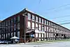 Manomet Mills |
24. Mai 2012 ID-Nr. 12000304 |
194-194R, 200 Riverside Ave. 41° 40′ 3″ N, 70° 55′ 12,1″ W |
New Bedford | |
| 23 | Merrill’s Wharf Historic District |  Merrill’s Wharf Historic District |
11. Nov. 1977 ID-Nr. 77000167 |
MacArthur Dr. 41° 37′ 59″ N, 70° 55′ 15″ W |
New Bedford | |
| 24 | Moreland Terrace Historic District |  Moreland Terrace Historic District |
3. Juni 1996 ID-Nr. 96000610 |
41° 37′ 40″ N, 70° 56′ 11″ W |
New Bedford | |
| 25 | New Bedford Gas and Edison Light Complex | 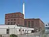 New Bedford Gas and Edison Light Complex |
3. Juni 2002 ID-Nr. 02000633 |
180 MacArthur Dr. 41° 37′ 49″ N, 70° 55′ 16″ W |
New Bedford | |
| 26 | New Bedford Historic District | 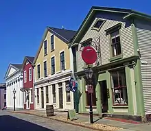 New Bedford Historic District weitere Bilder |
13. Nov. 1966 ID-Nr. 66000773 |
41° 38′ 7″ N, 70° 55′ 27″ W |
New Bedford | |
| 27 | New Bedford Whaling National Historical Park | 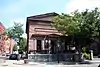 New Bedford Whaling National Historical Park |
12. Nov. 1996 ID-Nr. 03000283 |
33 William St. 41° 38′ 8,5″ N, 70° 55′ 26,6″ W |
New Bedford | |
| 28 | North Bedford Historic District |  North Bedford Historic District |
19. Sep. 1979 ID-Nr. 00000899 |
41° 38′ 25″ N, 70° 55′ 49″ W |
New Bedford | |
| 29 | Oak Grove Cemetery |  Oak Grove Cemetery |
28. Apr. 2014 ID-Nr. 14000176 |
Parker St. 41° 38′ 37,3″ N, 70° 56′ 31,9″ W |
New Bedford | |
| 30 | Old Third District Courthouse | 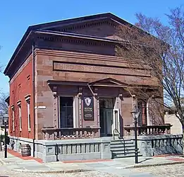 Old Third District Courthouse |
28. Sep. 1971 ID-Nr. 71000083 |
2nd und William Sts. 41° 38′ 9″ N, 70° 55′ 29″ W |
New Bedford | |
| 31 | Palmer Island Light Station |  Palmer Island Light Station |
26. März 1980 ID-Nr. 80000433 |
New Bedford Harbor 41° 37′ 34″ N, 70° 54′ 35″ W |
New Bedford | |
| 32 | William J. Rotch Gothic Cottage |  William J. Rotch Gothic Cottage weitere Bilder |
17. Feb. 2006 ID-Nr. 06000236 |
19 Irving St. 41° 37′ 49,8″ N, 70° 55′ 54,5″ W |
New Bedford | |
| 33 | William Rotch, Jr. House | 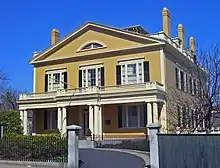 William Rotch, Jr. House weitere Bilder |
5. Apr. 2005 ID-Nr. 05000456 |
396 County Street 41° 37′ 49,1″ N, 70° 55′ 43,3″ W |
New Bedford | |
| 34 | Rural Cemetery and Friends Cemetery |  Rural Cemetery and Friends Cemetery |
28. Apr. 2014 ID-Nr. 14000177 |
149 Dartmouth St. 41° 37′ 22,4″ N, 70° 56′ 7,4″ W |
New Bedford | |
| 35 | Shawmut Diner | 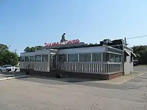 Shawmut Diner |
28. Nov. 2003 ID-Nr. 03001208 |
943 Shawmut Ave. 41° 39′ 32″ N, 70° 56′ 51″ W |
New Bedford | |
| 36 | Bradford Smith Building | 17. Mai 1984 ID-Nr. 84002216 |
1927-1941 Purchase St. 41° 39′ 4″ N, 70° 55′ 49″ W |
New Bedford | Nicht mehr existent. | |
| 37 | Thompson Street School |  Thompson Street School |
26. Jan. 1990 ID-Nr. 89002329 |
58 Crapo St. 41° 37′ 17″ N, 70° 55′ 37″ W |
New Bedford | |
| 38 | Times and Olympia Buildings | 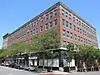 Times and Olympia Buildings |
7. Juli 1983 ID-Nr. 83000725 |
908-912 und 880-898 Purchase St. 41° 38′ 11″ N, 70° 55′ 36″ W |
New Bedford | |
| 39 | U.S. Customhouse | 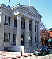 U.S. Customhouse weitere Bilder |
30. Dez. 1970 ID-Nr. 70000735 |
41° 38′ 7″ N, 70° 55′ 29″ W |
New Bedford | |
| 40 | Union Baptist Church | 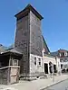 Union Baptist Church |
16. Juni 2008 ID-Nr. 08000532 |
109 Court St. 41° 38′ 3,1″ N, 70° 56′ 5,2″ W |
New Bedford | |
| 41 | Union Street Railway Carbarn, Repair Shop | 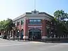 Union Street Railway Carbarn, Repair Shop |
2. Okt. 1978 ID-Nr. 78000431 |
1959 Purchase St. 41° 39′ 7″ N, 70° 55′ 52″ W |
New Bedford | |
| 42 | Wamsutta Mills |  Wamsutta Mills |
19. Aug. 2008 ID-Nr. 08000794 |
Acushnet Ave., Logan, Wamsutta und N. Front St. 41° 39′ 5,3″ N, 70° 55′ 39,5″ W |
New Bedford | |
| 43 | Whitman Mills | 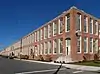 Whitman Mills |
29. Aug. 2003 ID-Nr. 03000844 |
41° 39′ 45″ N, 70° 55′ 10″ W |
New Bedford |
Siehe auch
Weblinks
Einzelnachweise
- Auszug aus dem National Register of Historic Places - Bristol County Abgerufen am 27. Dezember 2015
- Die Nummerierung in dieser Listenspalte ist an der vom National Park Service vorgelegten Reihenfolge der Einträge orientiert; die Farben unterscheiden verschiedene Schutzgebietstypen des National Park Systems mit landesweiter Bedeutung (z. B. National Historic Landmarks) von den sonstigen Einträgen im National Register of Historic Places.
- National Register Information System. In: National Register of Historic Places. National Park Service. Abgerufen am 24. April 2008.
| Countys |
Barnstable • Berkshire • Bristol • Dukes • Essex • Franklin • Hampden • Hampshire • Middlesex • Nantucket • Norfolk • Plymouth • Suffolk • Worcester (Nord | Süd) |
||||||||||||||||
| Städte |
|