Kangaroo Island Council
Der District Council of Kangaroo Island ist ein lokales Verwaltungsgebiet (LGA) im australischen Bundesstaat South Australia. Das Gebiet ist 4.400 km² groß und hat etwa 4700 Einwohner (2016).
| District Council of Kangaroo Island | |
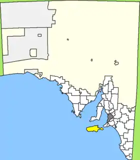 Lage des Kangaroo Island Council in South Australia | |
| Gliederung | |
| Staat: | |
| Bundesstaat: | |
| Verwaltungssitz: | Kingscote |
| Daten und Zahlen | |
| Fläche: | 4.400 km² |
| Einwohner: | 4.702 (2016) [1] |
| Bevölkerungsdichte: | 1,1 Einwohner je km² |
Kangaroo Island ist eine Insel vor der südaustralischen Küste vor dem Gulf Saint Vincent und ist etwa 110 Kilometer von der Metropole Adelaide entfernt. Auf der Insel liegen 19 Ortsteile und Ortschaften: American Beach, American River, Antechamber Bay, Brownlow, Cygnet River, Emu Bay, Flinders Chase, Harriet, Island Beach, Karatta, Kingscote, MacGillivray, Nepean Bay, Parndana, Penneshaw, Sapphiretown, Stokes Bay, Vivonne Bay und Wisanger. Der Verwaltungssitz des Councils befindet sich in Kingscote an der Nordostküste der Insel, wo etwa 1800 Einwohner leben (2016).[2]
Verwaltung
Der Council von Kangaroo Island hat zehn Mitglieder, die neun Councillor und der Vorsitzende und Mayor (Bürgermeister) des Councils werden von den Bewohnern der LGA gewählt. Kangaroo Island ist nicht in Bezirke untergliedert.
Einzelnachweise
- Australian Bureau of Statistics: Kangaroo Island (DC) (Local Government Area) (Englisch) In: 2016 Census QuickStats. 27. Juni 2017. Abgerufen am 20. April 2020.
- Australian Bureau of Statistics: Kingscote (Urban Centre/Locality) (Englisch) In: 2016 Census QuickStats. 27. Juni 2017. Abgerufen am 20. April 2020.