Hinunangan
Hinunangan ist eine philippinische Stadtgemeinde in der Provinz Southern Leyte auf der Insel Leyte. Sie hat 29.976 Einwohner (Zensus 1. August 2015), die in 40 Barangays leben. Die Gemeinde wird als teilweise urban beschrieben. Hinunangan liegt ca. 144 km östlich der Provinzhauptstadt Maasin City und ist von dort über den Maharlika Highway via der Gemeinde Sogod erreichbar. Die beiden der Küste vorgelagerten Inseln San Pedro und San Pablo gehören zum Verwaltungsgebiet der Gemeinde.
| Municipality of Hinunangan | |||
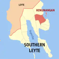
| Lage von Hinunangan in der Provinz Southern Leyte | |||
|---|---|---|---|
 | |||
| Basisdaten | |||
| Region: | Eastern Visayas | ||
| Provinz: | Southern Leyte | ||
| Barangays: | 40 | ||
| PSGC: | 086403000 | ||
| Einkommensklasse: | 3. Einkommensklasse | ||
| Haushalte: | Zensus 1. Mai 2000 | ||
| Einwohnerzahl: | 29.976 Zensus 1. August 2015 | ||
| Bevölkerungsdichte: | 175,7 Einwohner je km² | ||
| Fläche: | 170,58 km² | ||
| Koordinaten: | 10° 24′ N, 125° 12′ O | ||
| Postleitzahl: | 6608 | ||
| Bürgermeister: | Gomez, Romeo M | ||
| Geographische Lage auf den Philippinen | |||
| |||

In der Gemeinde befindet sich ein Campus der Southern Leyte State University.
Baranggays
|
|
|
This article is issued from Wikipedia. The text is licensed under Creative Commons - Attribution - Sharealike. The authors of the article are listed here. Additional terms may apply for the media files, click on images to show image meta data.