Grant Council
Der District Council of Grant ist ein lokales Verwaltungsgebiet (LGA) im australischen Bundesstaat South Australia. Das Gebiet ist 1.904 km² groß und hat etwa 8200 Einwohner (2016).
| District Council of Grant | |
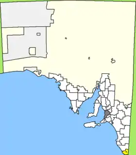 Lage des Grant Council in South Australia | |
| Gliederung | |
| Staat: | |
| Bundesstaat: | |
| Verwaltungssitz: | Mount Gambier |
| Daten und Zahlen | |
| Fläche: | 1.904 km² |
| Einwohner: | 8.203 (2016) [1] |
| Bevölkerungsdichte: | 4,3 Einwohner je km² |
Grant liegt im äußersten Südosten von South Australia an der Grenze zu Victoria etwa 380 km südöstlich der Metropole Adelaide und 370 km westlich von Melbourne. Das Gebiet beinhaltet 34 Ortsteile und Ortschaften: Allendale East, Blackfellows Caves, Burrungule, Canunda, Cape Douglas, Caroline, Carpenter Rocks, Caveton, Compton, Dismal Swamp, Donovans, Eight Mile Creek, German Creek, Glenburnie, Kongorong, Mil-Lel, Mingbool, Moorak, Mount Schank, Nene Valley, O B Flat, Pelican Point, Pleasant Park, Port Macdonnell, Racecourse Bay, Square Mile, Suttontown, Tantanoola, Tarpeena, Wandilo, Wepar, Worrolong, Wye und Yahl. Der Verwaltungssitz des Councils befindet sich in der Stadt Mount Gambier, die eine eigene LGA bildet, die vom Grant District umschlossen wird.
Verwaltung
Der Council von Grant hat zehn Mitglieder, neun Councillor werden von den Bewohnern der drei Wards gewählt (sieben aus dem Central Ward, je einer aus Tarpeena und Port MacDonnell Ward). Der Ratsvorsitzende und Mayor (Bürgermeister) wird zusätzlich von allen Bewohnern der City gewählt.
Weblinks
- Offizielle Seite des Grant District Council (englisch)
Einzelnachweise
- Australian Bureau of Statistics: Grant (DC) (Local Government Area) (Englisch) In: 2016 Census QuickStats. 27. Juni 2017. Abgerufen am 20. April 2020.