Goudiry (Département)
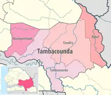
Das Département Goudiry ist eines von 45 Départements, in die der Senegal, und eines von vier Départements, in die die Region Tambacounda gegliedert ist. Es liegt im Südosten des Senegal mit der Hauptstadt Goudiry.

Département Goudiry in der Region Tambacounda
Das Département Goudiry wurde 2008 durch Ausgliederung aus dem Département Bakel geschaffen und umfasst dessen vorherigen Westteil mit einer Fläche von 17000 km².[1][2] Es gliedert sich wie folgt in Arrondissements, Kommunen (Communes) und Landgemeinden (Communautés rurales):[3][4]
| Commune / Arrondissement | Communauté rurale | Einwohner 2013 |
| Goudiry | — | 6.867 |
| Kothiary | — | 4.244 |
| Bala | Bala | 6.151 |
| Bala | Goumbayel | 5.224 |
| Bala | Koar | 8.512 |
| Boynguel Bamba (2008) | Boynguel Bamba | 11.584 |
| Boynguel Bamba (2008) | Dougué | 7.252 |
| Boynguel Bamba (2008) | Koussan | 7.698 |
| Boynguel Bamba (2008) | Sinthiou Mamadou Boubou | 13.687 |
| Dianké Makha (2008) | Bani Israël | 5.377 |
| Dianké Makha (2008) | Boutoucoufara | 5.735 |
| Dianké Makha (2008) | Dianké Makha | 7.109 |
| Dianké Makha (2008) | Komoti | 8.417 |
| Koulor (2008) | Koulor | 11.639 |
| Koulor (2008) | Sinthiou Bocar Ali | 5.351 |
| Département | — | 114.846 |
Einzelnachweise
- Goudiry, une ancienne communauté rurale de Bakel devient département Source:Tambacundainfo.com
- Service Régional de la Statistique et de la Démographie de Tambacounda: Situation economique et sociale regionale 2014 Fläche seit 2008: Seite 27 der PDF-Datei 2,02 MB
- DECRET n° 2008-747 du 10 juillet 2008 portant création de départements et d’arrondissements (Memento vom 2. August 2018 im Internet Archive)
- Service Régional de la Statistique et de la Démographie de Tambacounda: Situation economique et sociale regionale 2013 Einwohnerzahlen Seite 16 und 113 der PDF-Datei 1,10 MB
This article is issued from Wikipedia. The text is licensed under Creative Commons - Attribution - Sharealike. The authors of the article are listed here. Additional terms may apply for the media files, click on images to show image meta data.