Louga (Département)
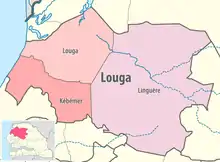
Das Département Louga mit der Hauptstadt Louga ist eines von 45 Départements, in die der Senegal, und eines von drei Départements, in die die Region Louga gegliedert ist. Es liegt im Nordwesten des Senegal zwischen der der Grande-Côte und dem Unterlauf des Flusses Ferlo und dem Südteil des Guiers-Sees.

Département Louga in der Region Louga
Das Département hat eine Fläche von 5649 km²[1] und gliedert sich wie folgt in Arrondissements, Kommunen (Communes) und Landgemeinden (Communautés rurales):[2][3]
| Commune / Arrondissement | Communauté rurale | Einwohner 2013 |
| Louga | — | 104.349 |
| Ndiagne (2011) | — | 7.496 |
| Coki | Coki | 25.298 |
| Coki | Pété Ouarack | 4.837 |
| Coki | Thiamène Cayor | 17.179 |
| Coki | Guet Ardo (2011) | 8.635 |
| Keur Momar Sarr | Gandé | 16.513 |
| Keur Momar Sarr | Keur Momar Sarr | 27.517 |
| Keur Momar Sarr | Nguer Malal | 24.518 |
| Keur Momar Sarr | Syer | 7.104 |
| Mbédiène | Kele Gueye | 10.091 |
| Mbédiène | Mbédiène | 12.442 |
| Mbédiène | Nguidilé | 19.710 |
| Mbédiène | Niomré | 15.822 |
| Sakal | Léona | 32.788 |
| Sakal | Ngueune Sarr | 13.874 |
| Sakal | Sakal | 25.037 |
| Département | — | 373.212 |
Einzelnachweise
- Service Régional de la Statistique et de la Démographie de Louga: Situation economique et sociale regionale Edition 2005 Fläche des Départements auf Seite 3 der PDF-Datei 0,96 MB
- Répartition spatiale der Region (Verwaltungsgliederung) auf Seite 7 und 8 der Edition 2005
- ANSD: Rapport Projection de la Population du Senegal 2013 - 2063 (RGPHAE 2013) Region Louga Seite 35 bis 37 der PDF-Datei 1,44 MB
This article is issued from Wikipedia. The text is licensed under Creative Commons - Attribution - Sharealike. The authors of the article are listed here. Additional terms may apply for the media files, click on images to show image meta data.