City and District of St Albans
City and District of St Albans ist ein Verwaltungsbezirk in Hertfordshire, England.
| City and District of St Albans | |
|---|---|
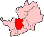 Lage in Hertfordshire | |
| Status | Borough und City |
| Region | East of England |
| Verw.grafschaft | Hertfordshire |
| Verwaltungssitz | St Albans |
| Fläche | 161,18 km² (205.) |
| Einwohner | 132.300 (142.) |
| ONS-Code | 26UG |
| Website | www.stalbans.gov.uk |
Zum Distrikt gehören
- Die City St Albans (ca. 58.000 Einwohner)
- die Stadt Harpenden (ca. 27.600 Einwohner)
- die Gemeinden Colney Heath, Harpenden Rural, London Colney, Redbourn, St Michael, St Stephen (einschl. der Orte Chiswell Green und Bricket Wood), Sandridge und Wheathampstead.
Der für einen Distrikt ungewöhnliche Name ist aus dem Umstand entstanden, dass in seinem Gebiet zwei städtische Gebiete und mehrere Ortschaften liegen. Normalerweise tragen Distrikte, in denen eine City liegt, auch nur den Namen City of (z. B. City of Peterborough).
Der Distrikt wurde 1974 durch einen Zusammenschluss des St Albans City Council, Harpenden Urban District Council und St Albans Rural District Council gebildet. Der offizielle Name des Distriktrats lautet zwar St Albans District Council, auf allen Fahrzeugen, Briefköpfen und der Webseite wird jedoch die Bezeichnung St. Albans City & District verwendet.
This article is issued from Wikipedia. The text is licensed under Creative Commons - Attribution - Sharealike. The authors of the article are listed here. Additional terms may apply for the media files, click on images to show image meta data.