Wolhynisches Hochland
Das Wolhynische Hochland (ukrainisch Волинська височина/Wolynska wyssotschyna, russisch Волынская возвышенность/Wolynskaja woswyschennost, polnisch Wyżyna Wołyńska) ist ein Hochland im Nordwesten der Ukraine.
| Wolhynisches Hochland (Волинська_височина) | |
|---|---|
 | |
| Höchster Gipfel | Misozkyj krjasch (Мізоцький кряж) (341 m) |
| Lage | Oblast Wolyn, Oblast Riwne, Oblast Lwiw und Oblast Chmelnyzkyj, Ukraine |
| Koordinaten | 50° 30′ N, 24° 24′ O |
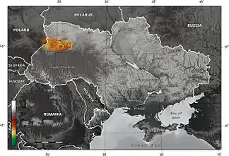
Das Hochland bildet zusammen mit der Podolischen Platte das Wolhynisch-Podolische Hochland, es erstreckt sich vom Bug im Westen bis zum Fluss Kortschyk (Корчик) im Osten über eine Länge von 200 Kilometern und 40 bis 50 Kilometern Breite über die Oblaste Wolyn, Riwne, Lwiw und Chmelnyzkyj.
This article is issued from Wikipedia. The text is licensed under Creative Commons - Attribution - Sharealike. The authors of the article are listed here. Additional terms may apply for the media files, click on images to show image meta data.