Vegetationsindex
Vegetationsindizes sind eine der primären Quellen für die Beobachtung und Analyse der Erdoberfläche und insbesondere der Vegetation. Sie nutzen den roten und nah-infraroten Spektralbereich. Zur Aufnahme können tragbare Handgeräte oder flugzeug- bzw. satellitengestützte Multispektralsensoren verwendet werden.

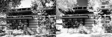
Normale Aufnahme (VIS) und Infrarotaufnahme (IR, rechts)

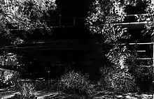
Differenzbild IR−VIS
Hintergrund
Vegetationsindizes machen sich den starken Anstieg des Reflexionsgrades photosyntheseaktiver Vegetation vom roten (ca. 630–690 nm) zum nah-infraroten (ca. 750–900 nm) Bereich zunutze. Chlorophyll, besser: Mesophyll, reflektiert im nahen Infrarot ungefähr sechsmal stärker als im sichtbaren Spektrum.
Publizierte Indizes

- VI ≈ DVI "Difference Vegetation Index" (NIR-Red) (Lillesand & Kiefer, 1987 (VI); Richardson & Everitt, 1992 (DVI)):
- RVI "Ratio Vegetation Index" (NIR/Red) (Jordan, 1969)
- WDVI
- NDVI "Normalized Differenced Vegetation Index"
- SAVI Familie "Soil Adjusted Vegetation Index"
- EVI "Enhanced Vegetation Index"
- GRABS "GReeness Above Bare Soil" (Hay et al., 1979)
- PVI "Perpendicular Vegetation Index" (Richardson & Wiegand, 1977)
Weitere spektrale Indizes
- Tasseled Cap
- VARI (Visible Atmospherically Resistant Index) (Gittelson et al., 2002)
- NDBI (Normalized Difference Built-up Index) (Zha et al., 2003)
- AFRI (Aerosol Free Vegetation Index) (Karnieli et al., 2001)
- ARVI (Aerosol Resistant Vegetation Index)
- MSI (Moisture Stress Index) (Rock et al., 1986)
- LWCI (Leaf Water Content Index) (Hunt et al., 1987)
Siehe auch
Weblinks
- NASA Measuring Vegetation (NDVI & EVI) – Earth Observatory
This article is issued from Wikipedia. The text is licensed under Creative Commons - Attribution - Sharealike. The authors of the article are listed here. Additional terms may apply for the media files, click on images to show image meta data.