Vaini (Distrikt)
Vaini ist einer der sieben Distrikte des Tongatapu-Atolls im Königreich Tonga im Pazifik.
| District Vaini Distrikt Vaini | |
|---|---|
| Basisdaten | |
| Staat | Tonga |
| Einwohner | 12.594 (2006) |
| ISO 3166-2 | TO-04 |
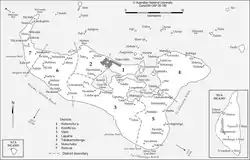 Karte der Distrikte von Tongatapu | |
Geographie
Der Distrikt liegt an der Südküste des Atolls und erstreckt sich bis zur Fuaʻamotu Beach, wo sich der Distrikt Tatakamotonga anschließt.[1] Der Distrikt grenzt im Westen an den Distrikt Nukunuku und im Norden an Kolomotuʻa, sowie an die zentrale Fangaʻuta Lagoon (Fanga Kakau Lagoon). Die Halbinsel von Folaha tritt fast bis an den Hauptstadtbezirk von Kolofoʻou heran.
Bevölkerung
Zum Distrikt gehören mehrere Siedlungen:[2]
| Dorf | Einwohner |
|---|---|
| Vaini | 3.091 |
| Malapo | 643 |
| Longoteme | 601 |
| Folaha | 893 |
| Nukuhetulu | 360 |
| Veitongo | 1.142 |
| Haʻateiho | 2.322 |
| Pea | 2.437 |
| Tokomololo | 1.105 |
Weblinks
- pmo.gov.to (toter Link)
Einzelnachweise
This article is issued from Wikipedia. The text is licensed under Creative Commons - Attribution - Sharealike. The authors of the article are listed here. Additional terms may apply for the media files, click on images to show image meta data.