Tokomololo
Tokomololo ist ein Ort der Inselgruppe Tongatapu im Süden des pazifischen Königreichs Tonga.
| Tokomololo | |||
|---|---|---|---|
| |||
| Koordinaten | 21° 11′ S, 175° 15′ W | ||
 | |||
| Basisdaten | |||
| Staat | Tonga | ||
|
Division |
Tongatapu | ||
| Distrikt | Vaini | ||
| Einwohner | 1276 (2016) | ||
Tokomololo hatte 2016 1276 Einwohner (Stand 2016).[1]
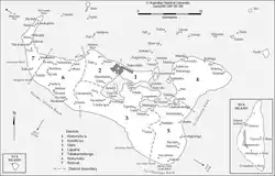
Geographie
Der Ort liegt südwestlich von Pea im Distrikt Vaini im Landesinnern an der Loto Road. Im Osten schließt sich Haʻateiho an.[2] Im Westen ist der nächste Ort Liahona. Im Ort gibt es eine Kirche der Church of Jesus Christ of Latter-day Saints.
Klima
Das Klima ist tropisch heiß, wird jedoch von ständig wehenden Winden gemäßigt. Ebenso wie die anderen Orte der Tongatapu-Gruppe wird Tokomololo gelegentlich von Zyklonen heimgesucht.
Literatur
- A. H. Wood: History and Geography of Tonga, Wilton and Horton, Nukuʻalofa 1938.
Einzelnachweise
- Tonga 2016 Census of Population and Housing. (PDF; 9,14 MB) Volume 1: Basic tables and administrative report. Tonga Statistics Department, Oktober 2017, abgerufen am 3. Februar 2021 (englisch).
- Tokomololo bei GeoNames, geonames.org. Abgerufen am 2. Februar 2021.
This article is issued from Wikipedia. The text is licensed under Creative Commons - Attribution - Sharealike. The authors of the article are listed here. Additional terms may apply for the media files, click on images to show image meta data.