Texa
Texa (gälisch: Teacsa) ist eine schottische Insel. In Joan Blaeus Atlas aus dem Jahre 1654 wird der Name der Insel als Ylen Teghza angegeben.
| Texa | ||
|---|---|---|
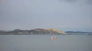 Südküste Texas | ||
| Gewässer | Atlantischer Ozean | |
| Inselgruppe | Innere Hebriden | |
| Geographische Lage | 55° 37′ 3″ N, 6° 8′ 32″ W | |
| ||
| Länge | 1,3 km | |
| Breite | 600 m | |
| Fläche | 48 ha | |
| Höchste Erhebung | Ceann Garbh 48 m | |
| Einwohner | unbewohnt | |
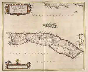 Ausschnitt aus Joan Blaeus Atlas aus dem Jahre 1654. Die Karte ist nach Westen ausgerichtet, wodurch Texa (TEGHZA) und die Islayküste am oberen Bildrand erscheinen. | ||
Geographie
Die Insel liegt 700 Meter südlich von Islay und etwa zwei Kilometer südöstlich des Fährhafens Port Ellen. Sie ist damit Teil der Inselgruppe Innere Hebriden und gehört administrativ zur Council Area Argyll and Bute. Historisch gehörte Texa zur Grafschaft Argyllshire.[1] Texa erstreckt sich auf einer Länge von 1,3 km in ostnordöstlicher Richtung bei einer Breite von maximal 600 m. Den höchsten Punkt der felsigen Insel bildet der im Nordosten befindliche Hügel Ceann Garbh mit einer Höhe von 48 m.[2]
Besiedlung
Während aus Zensusdaten aus dem Jahre 1861 hervorgeht, dass mit der Familie Logan noch eine neunköpfige Familie auf Texa lebte,[3] ist die Insel heute unbewohnt.[2] Auf Texa sind die Überreste einer Texa Chapel genannten Kapelle und eines Friedhofs erhalten. Es gibt Indizien, dass Texa identisch mit dem Oidecha aus klösterlichen Schriften ist. Der Heilige Kenneth (Cainneach), ein Gefährte des Heiligen Columban, soll hier auf seiner Reise von Iona gehalten haben.[2][4]
Einzelnachweise
- Texa. In: Francis H. Groome: Ordnance Gazetteer of Scotland: A Survey of Scottish Topography, Statistical, Biographical and Historical. Band 6: (Pet – Zet). Thomas C. Jack, Grange Publishing Works, Edinburgh u. a. 1885, S. 436.
- Texa. In: David Munro, Bruce Gittings: Scotland. An Encyclopedia of Places & Landscapes. Collins u. a., Glasgow 2006, ISBN 0-00-472466-6.
- Scotland Census Office: Census of Scotland–1861. Population Tables and Report. Number of the Inhabitants, Families, Children at School, Houses, and Rooms with Windows, in the Civil Counties and Parishes, Registration Counties and Districts, Burghs, Towns, Villages, and Islands of Scotland: Also a Classification of Families according to their Sizes, the Number of Persons they Contain, and their relative House Accommodation. Murray and Gibb for Her Majesty's Stationery Office, Edinburgh 1862.
- Hamish Haswell-Smith: The Scottish Islands.Aa comprehensive Guide to every Scottish Island. Fully revised 2nd edition. Canongate, Edinburgh u. a. 2004, ISBN 1-84195-454-3, S. 31.