Segula Island
Segula Island (aleutisch: Chigulax̂) ist eine Vulkaninsel der Aleuten und gehört zu den Rat Islands. Sie liegt westlich von Little Sitkin Island und hat Abmessungen von etwa 6 mal 7 km.
| Segula Island | ||
|---|---|---|
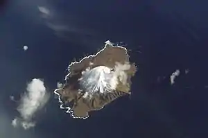 Satellitenbild von Segula Island | ||
| Gewässer | Pazifischer Ozean | |
| Inselgruppe | Rat Islands | |
| Geographische Lage | 52° 1′ 0″ N, 178° 8′ 0″ O | |
| ||
| Länge | 7 km | |
| Breite | 6 km | |
| Höchste Erhebung | 1153 m | |
| Einwohner | unbewohnt | |
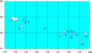 Karte der West-Aleuten/ 9 - Segula Island | ||
Die Vulkaninsel erreicht eine Höhe von 1153 m. Bis heute sind keine Eruptionen bekannt.
Weblinks
- Bild und Kurzbeschreibung (Memento vom 23. Dezember 2010 im Internet Archive)
- Segula Island im Global Volcanism Program der Smithsonian Institution (englisch)
This article is issued from Wikipedia. The text is licensed under Creative Commons - Attribution - Sharealike. The authors of the article are listed here. Additional terms may apply for the media files, click on images to show image meta data.