Santo Tomas (La Union)
Santo Tomas ist eine Stadtgemeinde in der philippinischen Provinz La Union und liegt am Golf von Lingayen. Im Jahre 2015 zählte sie 39.092 Einwohner. Das Gebiet ist teilweise sehr flach, steigt aber in Richtung Osten an.
| Municipality of Santo Tomas | |||
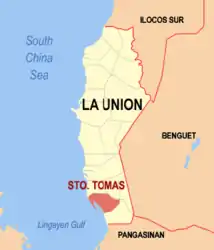
| Lage von Santo Tomas in der Provinz La Union | |||
|---|---|---|---|
 | |||
| Basisdaten | |||
| Region: | Ilocos-Region | ||
| Provinz: | La Union | ||
| Barangays: | 24 | ||
| Distrikt: | 2. Distrikt von La Union | ||
| PSGC: | 013317000 | ||
| Einkommensklasse: | 4. Einkommensklasse | ||
| Haushalte: | 5956 Zensus 1. Mai 2000 | ||
| Einwohnerzahl: | 39.092 Zensus 1. August 2015 | ||
| Koordinaten: | 16° 16′ N, 120° 24′ O | ||
| Postleitzahl: | 2505 | ||
| Bürgermeister: | Severino C. Carbonell | ||
| Geographische Lage auf den Philippinen | |||
| |||

Santo Tomas ist in folgende 24 Baranggays aufgeteilt:
|
|
This article is issued from Wikipedia. The text is licensed under Creative Commons - Attribution - Sharealike. The authors of the article are listed here. Additional terms may apply for the media files, click on images to show image meta data.