Saint-Bonnet-de-Montauroux
Saint-Bonnet-de-Montauroux ist eine Ortschaft in Okzitanien in Frankreich. Die bisher eigenständige, 32 km² umfassende Gemeinde des Kantons Langogne ging mit Wirkung vom 1. Januar 2017 mit Laval-Atger in der Commune nouvelle Saint Bonnet-Laval auf. Seither ist sie eine Commune déléguée.
| Saint-Bonnet-de-Montauroux | ||
|---|---|---|
.svg.png.webp)
|
| |
| Gemeinde | Saint Bonnet-Laval | |
| Region | Okzitanien | |
| Département | Lozère | |
| Arrondissement | Mende | |
| Koordinaten | 44° 49′ N, 3° 43′ O | |
| Postleitzahl | 48600 | |
| Ehemaliger INSEE-Code | 48139 | |
| Eingemeindung | 1. Januar 2017 | |
| Status | Commune déléguée | |

Geografie, Infrastruktur
Nachbarorte sind Saint-Christophe-d’Allier im Norden, Saint-Haon im Nordosten, Rauret im Osten, Fontanes im Südosten, Auroux im Süden, Laval-Atger im Südwesten und Saint-Symphorien im Westen.
Saint-Bonnet-de-Montauroux wird von der Route nationale 88 tangiert.

Der Bahnhof Chapeauroux in Saint-Bonnet-de-Montauroux
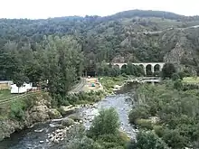
Viadukt von Chapeauroux
Bevölkerungsentwicklung
| Jahr | 1962 | 1968 | 1975 | 1982 | 1990 | 1999 | 2008 | 2014 |
|---|---|---|---|---|---|---|---|---|
| Einwohner | 279 | 262 | 228 | 220 | 146 | 128 | 133 | 101 |
Weblinks
Commons: Saint-Bonnet-de-Montauroux – Sammlung von Bildern, Videos und Audiodateien
This article is issued from Wikipedia. The text is licensed under Creative Commons - Attribution - Sharealike. The authors of the article are listed here. Additional terms may apply for the media files, click on images to show image meta data.