Rowley Island
Rowley Island ist eine Insel im Kanadisch-arktischen Archipel in der Qikiqtaaluk-Region des kanadischen Territorium Nunavut.
| Rowley Island | |
|---|---|
| Gewässer | Foxe Basin |
| Inselgruppe | Kanadisch-arktischer Archipel |
| Geographische Lage | 69° 6′ N, 78° 52′ W |
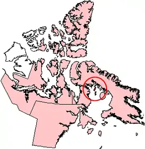 Lage von Rowley Island | |
| Länge | 69 km |
| Breite | 22 km |
| Fläche | 1 090 km² |
| Höchste Erhebung | 137 m |
| Einwohner | unbewohnt |
Sie liegt im Norden des Foxe Basin. Ihre Landfläche beträgt 1090 km².[1] Die Insel hat eine maximale Ausdehnung in Nord-Süd-Richtung von 69 km, sowie eine Breite von 22 km. Die höchste Erhebung erreicht 137 m.[2]
Die Insel ist unbewohnt. Auf Rowley Island befindet sich eine unbemannte Einrichtung der Distant Early Warning Line mit der Bezeichnung FOX-1 bei (69° 4′ 1″ N, 79° 3′ 54″ W), sowie eine automatisierte Wetterstation.
Die Insel wurde nach dem Polarforscher Graham Westbrook Rowley benannt.
Einzelnachweise
- Natural Resources Canada - The Atlas of Canada - Sea Islands
- UN SYSTEM-WIDE EARTHWATCH Web Site - Rowley
This article is issued from Wikipedia. The text is licensed under Creative Commons - Attribution - Sharealike. The authors of the article are listed here. Additional terms may apply for the media files, click on images to show image meta data.