Route 101 (Québec)
Die Route 101 ist eine Nationalstraße (Route nationale) der kanadischen Provinz Québec und führt durch die Verwaltungsregion Abitibi-Témiscamingue.
| Route 101 in Québec, Kanada | ||||||||||||||||||||||||||||||||||||||||||||||||||||||||||||||||
 | ||||||||||||||||||||||||||||||||||||||||||||||||||||||||||||||||
| Karte | ||||||||||||||||||||||||||||||||||||||||||||||||||||||||||||||||
 Verlauf der R 101 | ||||||||||||||||||||||||||||||||||||||||||||||||||||||||||||||||
| Basisdaten | ||||||||||||||||||||||||||||||||||||||||||||||||||||||||||||||||
| Betreiber: | Ministère des Transports du Québec | |||||||||||||||||||||||||||||||||||||||||||||||||||||||||||||||
| Straßenbeginn: | Témiscaming (46° 42′ 42″ N, 79° 5′ 59″ W) | |||||||||||||||||||||||||||||||||||||||||||||||||||||||||||||||
| Straßenende: | Macamic (48° 45′ 21″ N, 79° 0′ 8″ W) | |||||||||||||||||||||||||||||||||||||||||||||||||||||||||||||||
| Gesamtlänge: | 289,3 km | |||||||||||||||||||||||||||||||||||||||||||||||||||||||||||||||
 | ||||||||||||||||||||||||||||||||||||||||||||||||||||||||||||||||
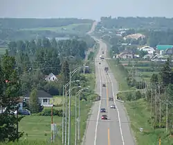
| Route 101 bei Saint-Bruno-de-Guigues | ||||||||||||||||||||||||||||||||||||||||||||||||||||||||||||||||
Straßenverlauf
| ||||||||||||||||||||||||||||||||||||||||||||||||||||||||||||||||
Streckenbeschreibung
Die 289,3 km lange Überlandstraße führt von Témiscaming, wo sie die nordöstliche Fortsetzung des Ontario Highway 63 bildet, in nördlicher Richtung über Ville-Marie, Notre-Dame-du-Nord und Rouyn-Noranda nach Macamic. Sie verläuft anfangs entlang dem Ostufer des Lac Témiscamingue.
Weblinks
Commons: Route 101 – Sammlung von Bildern, Videos und Audiodateien
- Carte routière officielle du Québec
- Ministère des Transports du Québec
- Site officiel des routes touristiques du Québec
This article is issued from Wikipedia. The text is licensed under Creative Commons - Attribution - Sharealike. The authors of the article are listed here. Additional terms may apply for the media files, click on images to show image meta data.