Rancho Point
Der Rancho Point (spanisch Punta Rancho ‚Satteldachspitze‘) ist eine markante, 170 m hohe und felsige Landspitze, die den östlichen Ausläufer von Deception Island im Archipel der Südlichen Shetlandinseln markiert.
| Rancho Point | ||
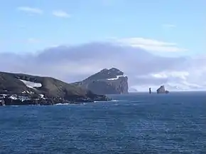 Rancho Point (Mitte) | ||
| Geographische Lage | ||
| ||
| Koordinaten | 62° 58′ S, 60° 30′ W | |
| Lage | Deception Island (Südliche Shetlandinseln) | |
| Gewässer | Bransfieldstraße | |

Der Kommandant des argentinisches Schiff Granville gab der Landspitze 1947 ihren deskriptiven Namen. Das Advisory Committee on Antarctic Names übertrug diese Benennung 1965 ins Englische.
Weblinks
- Rancho Point im Geographic Names Information System des United States Geological Survey (englisch)
- Rancho Point auf geographic.org (englisch)
This article is issued from Wikipedia. The text is licensed under Creative Commons - Attribution - Sharealike. The authors of the article are listed here. Additional terms may apply for the media files, click on images to show image meta data.