Raimuti Keousi
Raimuti Keousi ist ein osttimoresisches Dorf im Suco Saboria (Verwaltungsamt Aileu, Gemeinde Aileu).[1]
| Raimuti Keousi | |||
|---|---|---|---|
| |||
| Koordinaten | 8° 39′ S, 125° 38′ O | ||
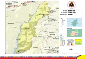 Karte des Sucos Saboria Karte des Sucos Saboria | |||
| Basisdaten | |||
| Staat | Osttimor | ||
| Aileu | |||
| Verwaltungsamt | Aileu | ||
| Suco | Saboria | ||
| Aldeia | Bermanuleu | ||
| Höhe | 1297 m | ||
Geographie
Raimuti Keousi liegt im Osten der Aldeia Bermanuleu. Etwa einen Kilometer weiter südlich liegt das Nachbardorf Bermanuleu, in dem sich die nächstgelegene Grundschule befindet sowie Gotteshäuser der Römisch-katholischen und Protestantischen Kirche in Osttimor (IPTL). Im Osten liegen im Suco Fahisoi (Verwaltungsamt Remexio) die Dörfer Dirohati und Estaurlatan.[1]
Einzelnachweise
- Direcção-Geral de Estatística: Atlas der Gemeinde Aileu, abgerufen am 21. März 2021.
This article is issued from Wikipedia. The text is licensed under Creative Commons - Attribution - Sharealike. The authors of the article are listed here. Additional terms may apply for the media files, click on images to show image meta data.