Przemyśler Land
Das Przemyśler Land (polnisch Ziemia przemyska) war eine Verwaltungseinheit der Polnisch-litauischen Adelsrepublik in der Woiwodschaft Ruthenien von 1434 bis 1772. Hauptort war Przemyśl.
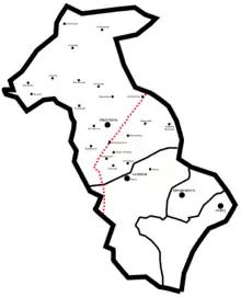
Kreise des Przemyśler Lands und die heutige staatliche Grenze

Fahne des Przemyśler und des Sanoker Landes in der Schlacht von Tannenberg 1410
Es umfasste die Powiat (Kreise)
- Powiat Przemyśl (Powiat przemyski), Hauptort Przemyśl
- Powiat Sambor (Powiat samborski), Hauptort Sambor
- Powiat Drohobycz (Powiat drohobycki), Hauptort Drohobycz
- Powiat Stryj (Powiat stryjski), Hauptort Stryj
1676 hatte das Przemyśler Land 32 Städtchen und 980 Dörfer.
Literatur
- K. Przyboś: Granice Ziemi Przemyskiej w czasach nowożytnych XVI–XVIII w. (Die Grenzen des Przemyśler Landes vom 16. bis 18. Jahrhundert), Przemyśl 1993.
- K. Arłamowski, u. a. (Hrsg.): Lustracja województwa ruskiego 1661–1665 (Wojewodschaft Ruthenien 1661–1665), Bd. 1: Ziemia przemyska i sanocka (Przemyśler und Sanoker Land). Wrocław, Warszawa, Kraków 1970.
This article is issued from Wikipedia. The text is licensed under Creative Commons - Attribution - Sharealike. The authors of the article are listed here. Additional terms may apply for the media files, click on images to show image meta data.