Ponta Bi Sé
Ponta Bi Sé ist ein Kap auf der osttimoresischen Insel Atauro, die der Landeshauptstadt Dili vorgelagert ist. Es liegt im Suco Macadade und bildet den westlichsten Punkt der Insel. Nördlich befindet sich das Dorf Maquer.[1]
| Ponta Bi Sé | ||
| Geographische Lage | ||
| ||
| Koordinaten | 8° 16′ S, 125° 30′ O | |
| Küste | Westküste Atauros | |
| Gewässer | Bandasee | |
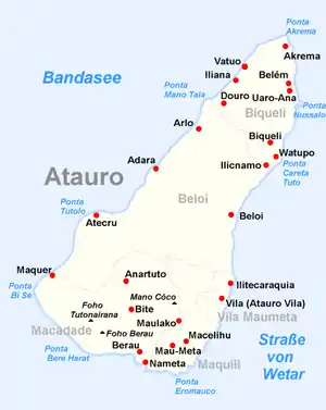 Karte von Atauro | ||
Einzelnachweise
- Timor-Leste GIS-Portal (Memento vom 30. Juni 2007 im Internet Archive)
This article is issued from Wikipedia. The text is licensed under Creative Commons - Attribution - Sharealike. The authors of the article are listed here. Additional terms may apply for the media files, click on images to show image meta data.