Pizzo Rotondo
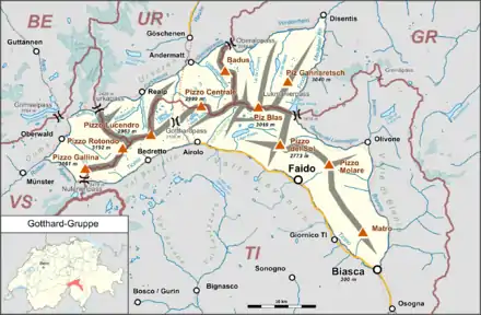
Der Pizzo Rotondo ist mit 3192 m ü. M. der höchste Berg des Gotthardmassivs in den Lepontinischen Alpen. Er liegt nördlich des Bedrettotals im Tessin und südöstlich des Geretals im Kanton Wallis auf der Kantonsgrenze.
| Pizzo Rotondo | ||
|---|---|---|

Pizzo Rotondo | ||
| Höhe | 3192 m ü. M. | |
| Lage | Kantonsgrenze Wallis / Tessin, Schweiz | |
| Gebirge | Gotthard-Gruppe, Lepontinischen Alpen | |
| Dominanz | 10 km → Gross Bielenhorn | |
| Schartenhöhe | 752 m ↓ Nufenenpass | |
| Koordinaten | 678848 / 152323 | |
| ||
| Gestein | Granit, Orthogneis | |
| Alter des Gesteins | Sakmarium | |
| Erstbesteigung | 17. Juli 1888 durch W. A. B. Coolidge und Christian Almer über den Südgrat[1] | |
Nördlich des Pizzo Rotondo liegt der Gerengletscher.
Weblinks
Commons: Pizzo Rotondo – Sammlung von Bildern, Videos und Audiodateien
- Pizzo Rotondo. summitpost.org (englisch)
- Pizzo Rotondo auf Peakbagger.com (englisch)
- Pizzo Rotondo auf der Plattform ETHorama
This article is issued from Wikipedia. The text is licensed under Creative Commons - Attribution - Sharealike. The authors of the article are listed here. Additional terms may apply for the media files, click on images to show image meta data.
