Panillo
| Gemeinde Graus: Panillo | |||
|---|---|---|---|
 Panillo | |||
| Wappen | Karte von Spanien | ||
| ? Hilfe zu Wappen |
| ||
| Basisdaten | |||
| Autonome Gemeinschaft: | |||
| Provinz: | Huesca | ||
| Comarca: | Ribagorza | ||
| Koordinaten | 42° 14′ N, 0° 18′ O | ||
| Höhe: | 822 msnm | ||
| Einwohner: | 77 (2019)INE | ||
| Postleitzahl: | 22438 | ||
| Ortskennzahl: | 22117001100 | ||


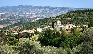
Panillo ist ein spanischer Ort in der Provinz Huesca der Autonomen Gemeinschaft Aragonien, der zur Gemeinde Graus gehört. Der Ort auf circa 700 Meter Höhe liegt circa fünf Kilometer nordwestlich von Graus. Panillo hatte im Jahr 2019 77 Einwohner.
Sehenswürdigkeiten
- Kirche San Cristóbal
- Buddhistisches Kloster
Literatur
- Huesca. Guía turística del Altoaragón. Editorial Pirineo, Huesca 2003, ISBN 84-87997-68-6, S. 176.
Weblinks
Commons: Panillo – Sammlung von Bildern, Videos und Audiodateien
.jpg.webp)
Kirche San Cristóbal
Ortsteile von Graus
Abenozas | Aguilar | Aguinalíu | Bafaluy | Bellestar | Benavente de Aragón | Cáncer | Castarlenas | Centenera | Ejep | El Soler | Erdao | Fantova | Grustán | Güel | Juseu | La Puebla de Fantova | La Puebla del Mon | Las Ventas de Santa Lucía | La Tosquilla | Panillo | Pano | Portaespana | Pueyo de Marguillén | Torre de Ésera | Torre de Obato | Torrelabad | Torres del Obispo | Torruella de Aragón
This article is issued from Wikipedia. The text is licensed under Creative Commons - Attribution - Sharealike. The authors of the article are listed here. Additional terms may apply for the media files, click on images to show image meta data.