Oblast Warna
| Basisdaten | |
|---|---|
| Region: | Ostbulgarien |
| Verwaltungssitz: | Warna |
| Fläche: | 3.820 km² |
| Einwohner: | 472.120 (2017) |
| Bevölkerungsdichte: | 123,6 Einwohner je km² |
| NUTS:BG-Code: | BG331 |
| Karte | |
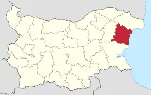 Karte | |
Die Oblast Warna (bulgarisch Област Варна) ist eine Verwaltungseinheit im Osten Bulgariens. Sie grenzt an das Schwarze Meer. Die größte Stadt der Region ist das gleichnamige Warna (auch: Varna).
Bevölkerung
In der Oblast (Bezirk) Warna leben 472.120 Einwohner auf einer Fläche von 3820 km².
Städte
| Stadt | Bulgarischer Name | Einwohner (31. Dezember 2018)[1] |
|---|---|---|
| Warna | Варна | 336.505 |
| Prowadija | Провадия | 12.075 |
| Dewnja | Девня | 7.786 |
| Aksakowo | Аксаково | 7.726 |
| Beloslaw | Белослав | 7.302 |
| Dolni Tschiflik | Долни чифлик | 6.378 |
| Suworowo | Суворово | 4.487 |
| Dalgopol | Дългопол | 4.438 |
| Ignatievo | Игнатиево | 3.955 |
| Waltschidol | Вълчидол | 2.857 |
| Bjala | Бяла | 2.087 |
Einzelnachweise
- Population by towns and sex. In: nsi.bg. Republic of Bulgaria – National Statistical Institute (NSI), 12. April 2019, abgerufen am 5. Mai 2019 (englisch).
Blagoewgrad | Burgas | Chaskowo | Dobritsch | Gabrowo | Jambol | Kardschali | Kjustendil | Lowetsch | Montana | Pasardschik | Pernik | Plewen | Plowdiw | Rasgrad | Russe | Schumen | Silistra | Sliwen | Smoljan | Sofia-Region | Sofia-Stadt | Stara Sagora | Targowischte | Warna | Weliko Tarnowo | Widin | Wraza
This article is issued from Wikipedia. The text is licensed under Creative Commons - Attribution - Sharealike. The authors of the article are listed here. Additional terms may apply for the media files, click on images to show image meta data.