Nuʻulopa
Nuʻulopa ist eine kleine unbewohnte Insel in der Apolima Strait von Samoa. Sie gehört administrativ zum Distrikt Aiga-i-le-Tai.
| Nuʻulopa | ||
|---|---|---|
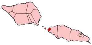 Karte von Aiga-i-le-Tai | ||
| Gewässer | Pazifischer Ozean | |
| Inselgruppe | Samoa | |
| Geographische Lage | 13° 51′ S, 172° 8′ W | |
| ||
 Fahrt nach Nu'ulopa im Boot. Das Dorf Apolima Tai auf Apolima rechts und Savai'i im Hintergrund. | ||
Geographie

Nuʻulopa erreicht eine Höhe von ca. 50 m. Die Insel fußt auf einem untermeerischen Höhenzug zwischen Upolu und Savaiʻi. Die felsige Insel trägt einige Kokospalmen (Cocos nucifera) und ist Schutzgebiet für Flughunde und Meeresschildkröten.[1] 2006 wurde Nuʻulopa mit den beiden Nachbarinseln Manono und Apolima als Kandidat für das UNESCO-Welterbe in die Tentativliste von Samoa eingetragen.[2]
Nuʻulopa dient auch als Friedhof für die Häuptlinge (matai) von Manono.
Klima
Das Klima ist tropisch heiß, wird jedoch von ständig wehenden Winden gemäßigt. Ebenso wie die anderen Inseln von Samoa wird Nuʻulopa gelegentlich von Zyklonen heimgesucht.
Einzelnachweise
- Nuʻulopa bei GeoNames, geonames.org Abgerufen am 14. Juli 2020.
- unesco.org: Manono, Apolima and Nuulopa Cultural Landscape, Unesco. Abgerufen 25. Oktober 2009.