Nootka Island
Nootka Island ist eine Insel an der Westküste von Vancouver Island, in British Columbia (Westkanada), mit einer Fläche von 510 km² und einem Umfang von 187 km.[1] Sie wird durch den Nootka Sound von Vancouver Island getrennt.
| Nootka Island | ||
|---|---|---|
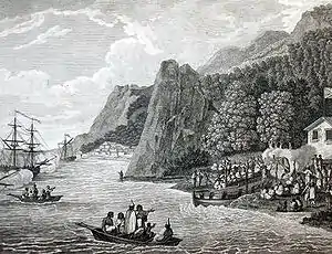 Schiffe von Meares vor Nootka Island | ||
| Gewässer | Pazifischer Ozean | |
| Geographische Lage | 49° 44′ N, 126° 46′ W | |
| ||
| Fläche | 510 km² | |
Der Name der Insel stammt vom indigenen Volk der Nuu-chah-nulth (Nootka) auf Vancouver Island ab.[2]
Wer die Insel als erster Europäer entdeckte, ist nicht sicher. Sowohl James Cook wie auch schon vor ihm Juan José Pérez Hernández besegelten die Küsten der Gegend. Der britische Seefahrer John Meares gilt als möglicher erster Europäer, welcher die Insel 1788 betrat.
Weblinks
Einzelnachweise
- The Atlas of Canada. Sea Islands. (Nicht mehr online verfügbar.) Natural Resources Canada, archiviert vom Original am 22. Januar 2013; abgerufen am 28. September 2015.
- Andrew Scott: The Encyclopedia of Raincoast Place Names: A Complete Reference to Coastal British Columbia. Harbour Publishing, Madeira Park, BC 2009, ISBN 978-1-55017-484-7, S. 429–430 (englisch).
This article is issued from Wikipedia. The text is licensed under Creative Commons - Attribution - Sharealike. The authors of the article are listed here. Additional terms may apply for the media files, click on images to show image meta data.