Newcomb Bay
Die Newcomb Bay ist eine geschützte Nebenbucht der Vincennes Bay an der Budd-Küste des ostantarktischen Wilkeslands. Sie liegt zwischen der Clark-Halbinsel und der Bailey-Halbinsel nahe den Windmill-Inseln.
| Newcomb Bay | ||
|---|---|---|
| Gewässer | Vincennes Bay | |
| Landmasse | Wilkesland, Ostantarktika | |
| Geographische Lage | 66° 16′ 0″ S, 110° 32′ 0″ O | |
| ||
| Länge | 1,6 km | |
| Inseln | Bailey Rocks, Bøving Island, Fitzpatrick Rock, Kilby Island, McMullin Island, Orton Reef | |
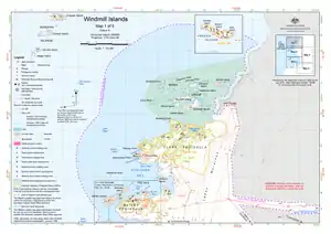 Karte der nördlichen Windmill-Inseln mit der Newcomb Bay (unterhalb der Mitte) Karte der nördlichen Windmill-Inseln mit der Newcomb Bay (unterhalb der Mitte) | ||

Erstmals kartiert wurde sie anhand von Luftaufnahmen der United States Navy, die im Februar 1947 während der Operation Highjump entstanden. Der US-amerikanische Ozeanograph Willis L. Tressler (1903–1973) nahm im Februar 1957 eine Vermessung der Bucht vor und benannte sie nach Leutnant Robert Carl Newcomb (1926–2008), Navigator des Eisbrechers USS Glacier.
Weblinks
- Newcomb Bay im Geographic Names Information System des United States Geological Survey (englisch)
- Newcomb Bay auf geographic.org (englisch)
- Newcomb Bay im Composite Gazetteer of Antarctica (englisch)
- Karte der Windmill-Inseln und Umgebung (PDF, März 2009) beim Australian Antarctic Data Centre (Beschreibung)
This article is issued from Wikipedia. The text is licensed under Creative Commons - Attribution - Sharealike. The authors of the article are listed here. Additional terms may apply for the media files, click on images to show image meta data.