New London (Missouri)
New London ist eine Kleinstadt am Mittellauf des Mississippi im US-amerikanischen Bundesstaat Missouri und Verwaltungssitz des Ralls County.
| New London (Missouri) | |
|---|---|
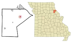 Lage in Missouri | |
| Basisdaten | |
| Gründung: | 1819 |
| Staat: | Vereinigte Staaten |
| Bundesstaat: | Missouri |
| County: | Ralls County |
| Koordinaten: | 39° 35′ N, 91° 24′ W |
| Zeitzone: | Central (UTC−6/−5) |
| Einwohner: | 943 (Stand: 2020) |
| Fläche: | 1,8 km² (ca. 1 mi²) davon 1,8 km² (ca. 1 mi²) Land |
| Postleitzahl: | 63459 |
| Vorwahl: | +1 573 |
| FIPS: | 29-52058 |
| GNIS-ID: | 0723280 |
Die Stadt liegt an der Schnittstelle des U.S. Highways 61 und der Missouri State Route 19. New London hatte bei der letzten Volkszählung der USA im Jahre 2000 genau 1001 Einwohner.
This article is issued from Wikipedia. The text is licensed under Creative Commons - Attribution - Sharealike. The authors of the article are listed here. Additional terms may apply for the media files, click on images to show image meta data.