Nagara (Fluss)
Der Nagara (jap. 長良川, Nagara-gawa) ist ein Fluss auf der japanischen Hauptinsel Honshū. Er ist 166 km lang und hat ein Einzugsgebiet von 1.985 km².
| Nagara | ||
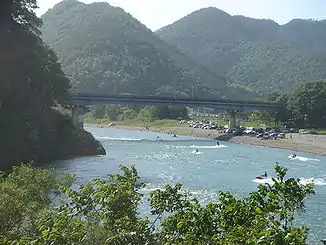 Der Nagara bei Gifu Der Nagara bei Gifu | ||
| Daten | ||
| Lage | Japan. Präfekturen Aichi, Gifu und Mie | |
| Flusssystem | Nagara | |
| Quelle | Am Berg Dainichigatake | |
| Mündung | Ise-Bucht 35° 1′ 35″ N, 136° 43′ 5″ O | |
| Mündungshöhe | 0 m
| |
| Länge | 166 km | |
| Einzugsgebiet | 1985 km² | |
Durch das Tal führt 2020 noch die Bahnstrecke der Etsumi-nan-Linie, die parallel verlaufende Minomachi-Linie legte man 2005 still.
Verlauf des Flusses
Der Nagara durchfließt folgende Orte:
- Präfektur Gifu:
- Präfektur Aichi:
- Präfektur Mie:
Literatur
- Akihisa Yoshikoshi: Comparative Research on the Hydrological Characteristics of some British and Japanese Drainage Basins. In: John Sargent & Richard Wiltshire (Hrsg.): Geographical Studies & Japan. Japan Library, Sandgate, Folkestone, Kent 1993, ISBN 1-873410-15-8., S. 89–94.
Weblinks
Commons: Nagara – Sammlung von Bildern, Videos und Audiodateien
This article is issued from Wikipedia. The text is licensed under Creative Commons - Attribution - Sharealike. The authors of the article are listed here. Additional terms may apply for the media files, click on images to show image meta data.